Search This Blog

Thursday, April 12, 2012

Easter Complex and Shipwereck Wildfire Update


Maps produced by the Virginia Department of Forestry used to help evaluate various challanges with an event such as this. One of those challanges is projecting the wildfires growth potential and its current and future impact of people, homes, businesses and resources in the Wildland Urban Interface.


Fire Information Number for overall fire situation and public inquiries : 
Marq Webb (404) 354-6005 or Michael Williams (540) 525-1539
Fire Information Email-  eastercomplex2012@gmail.com
Incident Management Team is based at the Buena Vista Work Center.

Six fires have burned 20,288 acres.
Over 360 people are assigned to these fires from 23 states including AL, AR, AZ, CO, FL, GA, ID, KY, LA, MI, MN, MS, MT, NC, NM, OK, OR, SC, TN, TX, UT, VA, & WV.


Lee RD:
Wolf Gap Fire (4/12/2012 @ 5:00 p.m.)
PIO- Stephanie Bushong (540) 984-4101. 
Location- Hardy Co. West Virginia and Shenandoah Co. VA
Total Acres: 650 acres primarily on national forest in the Wolf Gap area.
Many road and trail closures- please see official update for details.
Firefighters are working to protect Wolf Gap Campground.
Fire was detected Sunday afternoon 4/8/12.  Cause is undetermined. 
Total Personnel Assigned:  46

Shipwreck Fire (4/12/2012 @ 3:30 p.m.)
PIO- Cindy Frenzel (540) 333-3784
Location- Fire is west of the town of Shenandoah on the Page/Rockingham County Line, east of Harrisonburg. 
Total Acres: 5,971 acres.
Fire was detected on 4/8/12; Fire cause is under investigation.


James River RD:
Alleghany Tunnels Fire (4/12/2012 @ 5:00 p.m.)
PIO’s Alan Craft and Karen Grubbs (540) 962-2214
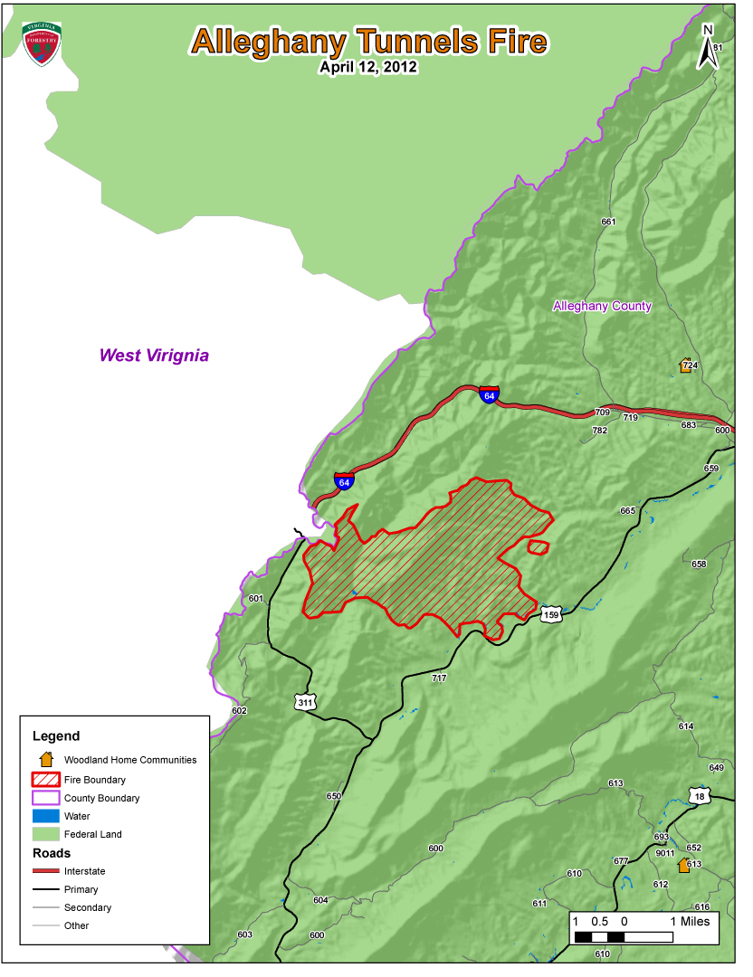
Location- The Alleghany Tunnels Fire is burning in a remote location 10 miles west of Covington, Alleghany County.  Fire is in the Dunlap Creek drainage of western Alleghany County.
Total acres: 7,656
Forest Roads 69 and 345 are closed.
Smoke visible on I64, SR 311 and SR 59. 
Fire reported 4/7/2012 and cause is undetermined.
Total Personnel Assigned:  56

Rich Hole Fire (4/12/2012 @ 5:00 p.m.)
PIO’s Alan Craft and Karen Grubbs (540) 962-2214
Location- 17 miles east of Covington in the Simpson Creek drainage of eastern Alleghany County and western Rockbridge County.  Estimated 80% of fire is burning in the Rich Hole Wilderness.  Fire is burning on private land and national forest.
Total acres:  3,669
SR 60 (between I-64 Exit 35 and 43)
Fire reported 4/9/2012 at 7:00 p.m. and cause is under investigation.
Total Personnel Assigned: 180

Eastern Divide RD:
Barbours Creek Fire (4/12/2012 @ 5:00 p.m.)
PIO: Barb Walker @ New Castle Work Station (540) 864-5195
Location- Potts Mountain along the Craig/Alleghany Line, 15 miles north of New Castle.  The fire is in Barbours Creek Wilderness and extends into Alleghany and Craig counties.
Total Acres:  2,685 acres
The four residences located northeast of the fire have been secured.  Residences on the northwest corner are the priority today.
Potts Mountain Jeep Trail  and Pines Campground are closed.  Please use caution when driving Barbours Creek Road (SR 617).
Fire was reported on 4/7/2012; cause is undetermined.
Total Personnel Assigned: 82 firefighters plus support staff

Glenwood & Pedlar Ranger Districts:
Cove Mountain Fire (4/12/2012 @ 5:00 p.m.)
PIO- JoBeth Brown (540) 265-5102
57 acres burning in remote area near Arcadia in Botetourt County.
The AT was closed from Saturday morning until Monday morning.  The fire did not reach the trail.
No structures threatened, no roads/trails closed.
Possible smoke visible from I-81
Total Personnel Assigned:  19


News Release
For Immediate Release                                                                                      April 12, 2012
Contact: John Campbell 434.220.9070 or 434.989.0665                                        VDOF 12035

Wildfires Burning on 19,717 Acres in Virginia

Five large wildfires and several small ones are burning more than 19,700 acres across the Commonwealth today.  While most of the large fires are on National Forest System land, the Virginia Department of Forestry, USFS, National Park Service along with numerous volunteer fire departments are out in force battling the blazes to protect lives and property.  They are being aided by federal resources from 22 other states (Alabama, Arkansas, Arizona, Colorado, Florida, Georgia, Idaho, Kentucky, Louisiana, Michigan, Minnesota, Mississippi, Montana, North Carolina, New Mexico, Oklahoma, Oregon, South Carolina, Tennessee, Texas, Utah and West Virginia).

Several Virginia state agencies, including the Departments of Emergency Management, State Police, Transportation and Fire Programs, continue to support the efforts. 

A combination of high winds, low humidity and no precipitation enabled the wildfires to grow and spread quickly.  Many of the fires are on steep, rocky terrain making it difficult for firefighters to reach the flames.

The Shipwreck Fire in Page County has already burned more than 5,000 acres and spans more than 5.5 miles in length – nearly the entire length of First Mountain.  Firefighters working this wildland fire have protected more than 125 homes and other structures thus far.  Several roads and trails are closed.  The cause of the fire is under investigation.    
Ten structures are threatened in the Barbours Creek Fire burning in Alleghany and Craig counties.  More than 2,685 acres have burned thus far, and the fire is 30 percent contained.

The Alleghany Tunnels Fire is burning in a remote location 10 miles west of Covington in Alleghany County.  A total of 7,656 acres have burned, and Forest Roads 69 and 345 are closed.  Smoke is visible on I-64, SR 311 and SR 59.  The fire was reported Saturday and cause has not been determined.  Ten structures have been protected.
The Wolf Gap Fire in Shenandoah County has burned approximately 650 acres primarily on national forest in the Wolf Gap area.  Numerous roads and trails have been closed.  Firefighters are working to protect the Wolf Gap Campground.  Driving visibility in area is limited due to smoke.  The fire was detected Sunday afternoon and the cause is undetermined. 
The Rich Hole Fire (17 miles east of Covington) has burned 3,669 acres and is threatening 10 structures.   Approximately 80 percent of the fire is burning in the Rich Hole Wilderness Area.  The fire is burning on private land and National Forest System land.  The fire was reported Monday at 7 p.m. and the cause is under investigation.
Several smaller fires are burning in several counties across Virginia.  The statewide 4 p.m. Burn Law – which restricts burning until after 4 p.m. each day – is in effect until April 30th.  Several counties, including Caroline, Highland and Rockbridge, have enacted 24-hour burn bans that remain in effect until further notice.  Forestry officials are asking all Virginians not to burn for the next several days and to keep their cigarette butts in their vehicles.

The Virginia Department of Forestry protects and develops healthy, sustainable forest resources for Virginians.  Headquartered in Charlottesville, the Agency has forestry staff members assigned to every county to provide citizen service and public safety protection across the Commonwealth.  VDOF is an equal opportunity provider.
With nearly 16 million acres of forestland and more than 144,000 Virginians employed in forestry, forest products and related industries, Virginia forests provide more than $27.5 Billion annually in benefits to the Commonwealth. 
-end-

Easter Complex Map

Red Flag warnings lifted Fire Danger continues

Map Virginia fires 4-11-2012
Map of fires in Virginia April 11, 2012
Updated at 4:33 p.m. MT, April 11, 2012; original article: 10:54 a.m. MT
Interstate 64 in western Virginia was closed in two places for 20 hours due to wildfires on Tuesday and Wednesday. It reopened around 2 p.m. EDT on Wednesday. Large fires are burning in the counties of Alleghany, Craig, Bath, Rickbridge, Page, Rockhingham, Shenandoah, and Stafford. Just across the state line in West Virginia there are other large fires in Greenbrier and Pocahontas counties.
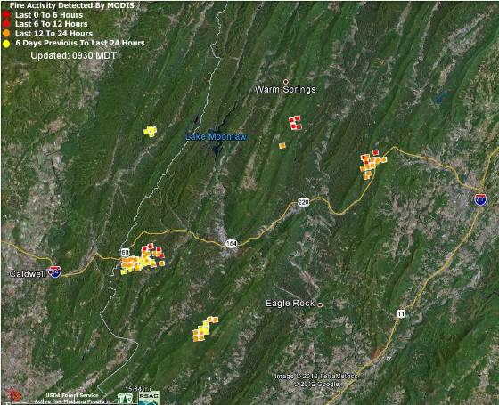
A heat-detecting satellite produced the data on the map above that shows the Virginia fires in the counties of Alleghany, Craig, Bath, and Rockbridge, as well as one fire in West Virginia. The white line running generally north and south is the state line between West Virginia and Virginia.
Mike Quesinberry’s Southern Area Blue Type 1 Incident Management Team is managing five fires that make up the Easter Complex north of Roanoke. Three of those fires are Barbours Creek (1,200 a.), Shipwreck (4,750 a.), and Alleghany Tunnels (6,000 a.). The Shipwreck fire in Page and Rockingham counties is just west of Shenandoah, Virginia. On Tuesday the weather was fairly conducive to fire spread. The relative humidity dropped to 8 percent but the wind speed was 2 to 5 MPH with gusts at 8 to 15. The temperature Tuesday night dropped into the mid-30s, and as of 6:07 p.m. EDT on Wednesday at the Craig Valley weather station it was 45 degrees, the RH was 34%, and the wind was northwest at 3 mph.

Wednesday, April 11, 2012

3rd straight day with RED FLAG WARNINGS, DOF News Release Video clips and Pictures


URGENT - FIRE WEATHER MESSAGE
NATIONAL WEATHER SERVICE
359 AM EDT WED APR 11 2012

...CRITICAL FIRE WEATHER CONDITIONS CONTINUE TODAY...

.THE COMBINATION OF GUSTY WINDS BEHIND A PASSING COLD FRONT...LOW
HUMIDITY LEVELS AND DRY FUELS WILL AGAIN MAKE FOR VERY HIGH FIRE
DANGER THIS AFTERNOON.


...RED FLAG WARNING IN EFFECT FROM NOON TODAY TO 8 PM EDT THIS
EVENING FOR THE COMBINATION OF GUSTY WINDS...LOW RELATIVE
HUMIDITIES...AND DRY FUELS...

THE NATIONAL WEATHER SERVICE HAS ISSUED A RED FLAG
WARNING FOR CRITICAL FIRE CONDITIONS...WHICH IS IN EFFECT FROM
NOON TODAY TO 8 PM EDT THIS EVENING.

* WINDS...NORTHWEST 10 TO 20 MPH WITH GUSTS UP TO 35 MPH.

* TIMING...NOON THROUGH 8 PM.

* RELATIVE HUMIDITY...AS LOW AS AROUND 20 PERCENT.

* TEMPERATURES...IN THE UPPER 40S TO LOWER 50S.

* IMPACTS...LIMITED RECENT RAINFALL HAS RESULTED IN DRY FUELS
  ACROSS THE REGION. RELATIVE HUMIDITY AND WIND SPEEDS WILL BE
  NEAR OR ABOVE CRITICAL FIRE WEATHER THRESHOLDS FOR A RED FLAG
  WARNING THIS AFTERNOON INTO EARLY THIS EVENING...CREATING
  DANGEROUS FIRE WEATHER CONDITIONS. GUSTY WINDS CAN RESULT IN
  ERRATIC FIRE WEATHER BEHAVIOR.

PRECAUTIONARY/PREPAREDNESS ACTIONS...

A RED FLAG WARNING MEANS THAT CRITICAL FIRE WEATHER CONDITIONS
ARE EITHER OCCURRING NOW...OR WILL SHORTLY. A COMBINATION OF
STRONG WINDS...LOW RELATIVE HUMIDITY...AND WARM TEMPERATURES WILL
CREATE EXPLOSIVE FIRE GROWTH POTENTIAL.


News Release
 
For Immediate Release                                                                                                April 10, 2012
Contact: John Campbell 434.220.9070 or 434.989.0665                                            VDOF 12031

Wildfires Burning 7,000 Acres in Virginia

Five large wildfires and many more small ones are burning more than 7,000 acres across the Commonwealth today.  While the bulk of the large fires are on US Forest Service land, the Virginia Department of Forestry, USFS, National Park Service along with numerous volunteer fire departments are out in force battling the blazes to protect lives and property.

“We’ve seen a tremendous uptick in fire activity today,” said John Miller, VDOF’s director of resource protection.  “It would be fair to say that all 180 of our wildland firefighters are involved in suppression efforts today, and resources are at or near capacity.”

A combination of high winds, low humidity and no precipitation has enabled the wildfires to grow and spread quickly.  Many of the fires are on steep, rocky terrain making it difficult for firefighters to reach the flames.

The Shipwreck Fire in Page County has already burned more than 1,850 acres and has the potential to reach 3,000 acres before it is controlled.  Firefighters working this wildland fire have protected 125 homes and other structures thus far.

Ten structures are threatened in the Barbers Creek Fire burning in Alleghany and Craig counties.  More than 1,500 acres have burned thus far, and the fire has the potential to reach 3,000 acres before being controlled.

The Alleghany Tunnel Fire has burned 2,500 acres and is 10 percent contained.  Ten structures have been protected.

The Wolf Gap Fire in Shenandoah County has the potential to reach 6,000 acres – it has burned 550 acres so far.

The Rich Hole Fire in Alleghany County has closed parts of I-64 in both directions.  The 400-acre blaze is threatening 10 structures.

Several smaller fires are burning in several counties across Virginia.  A Red Flag Warning for much of the Commonwealth and the 4 p.m. Burn Law – which restricts burning until after 4 p.m. each day – remain in effect.  Forestry officials are asking all Virginians not to burn for the next several days and to keep their cigarette butts in their vehicles.

The Virginia Department of Forestry protects and develops healthy, sustainable forest resources for Virginians.  Headquartered in Charlottesville, the Agency has forestry staff members assigned to every county to provide citizen service and public safety protection across the Commonwealth.  VDOF is an equal opportunity provider.
With nearly 16 million acres of forestland and more than 144,000 Virginians employed in forestry, forest products and related industries, Virginia forests provide more than $27.5 Billion annually in benefits to the Commonwealth. 
-end-


The following video and some pictures were obtained from various news stories being run accross Virginia. The Department of Forestry is very greatful for the support and coverage being provided. It is only with awarness and education during times like this that we can hope to reduce the number of human caused wildfires. THANKS to all reporters and camera folks and support personnel involved.
Smokey Bear


A fire threat has been issued for Sunday night. High winds and dry brush are fueling wildfires across central Virginia.
In Fluvanna County a pair of buzzards got zapped by power lines, fell to the ground and ignited a brush fire that quickly spread to two acres. The fire shut down Route 6 near Central Plains Road for almost four hours.
And in Schuyler, seven trucks from the Scottsville and Farber's Fire Department rushed to the end of Firefly Court around 6 p.m. to put out a brushfire. Flames stretched over 4 to 5 acres of land.
The fire was ignited by a property owner who a started small brush fire to clear land for a potential house site. Wind and dry leaves caused the flames to spread rapidly.
Timmy Ceresley of the Scottsville Volunteer Fire Department said, "Once we get the line around it, with the tractor in place, we'll go back through working any hot spots looking for anything that could potentially set fire across the line."


A wildfire has forced a stretch of Interstate 64 to be closed in Alleghany and Rockbridge counties.
Virginia highways officials say I-64 was closed in both directions Tuesday from exit 29 near Nicelytown to exit 50 near Lexington and Kerrs Creek.
Eastbound traffic on I-64 is being rerouted near Clifton Forge and Iron Gate on to Route 220. Westbound traffic from I-81 headed to I-64 is being detoured at exit 150 onto Route 220.


Tuesday, April 10, 2012

The following pictures are from the Shipwreck Fire.


STATE WIDE Situation Report
Summary: Combination of dry fuels, winds 15-25 mph with gusts up to 40 mph, relative humidity values ranging from 15%-30%, and temperatures in upper 50s to low 60s have created third consecutive day of Red Flag Warnings  across Virginia. Since Sunday, 9 April, initial Virginia Department of Forestry (VDOF) reports 40 fires have burned approximately 192 acres on private land and approximately 135 residences/structures have been protected. The following fires are primarily on National Forest land.

§  Page County, Shipwreck Fire, current estimated acreage burned – 1,853. Fire started Sunday, 8 April, on private land and is now mostly on National Forest land. Fire is 30% contained
§  Craig County, Barbours Creek Fire, current estimated acreage burned – 1,500. Fire started Sunday, 8 April, on National Forest land and is 0% contained. . 
§  Shenandoah County, Wolf Gap Fire, current estimated acreage burned – 550; projected to be 6,000 acres. Fire started Sunday, 8 April, on National Forest land and is 0% contained.
§  Botetourt County, Cove Mountain Fire, current estimated acreage burned – 75. Fire on National Forest land.
§  Alleghany County, Alleghany Tunnel Fire, current estimated acreage burned – 2,500. Fire started Sunday, 8 April, on National Forest land and is 0% contained. .
§  Alleghany County, Rich Hole Fire, current estimated acreage burned – 100. Fire started Monday, 9 April, on National Forest land and is 0% contained.
§  Giles County, current estimated acreage burned – 5. Fire is on National Forest land and 0% contained
Emergency Declarations: 1
Page County 11:44 on 10 April
Local Actions:
  • Page County requested resources through Statewide Mutual Aid (SMA):
    • 5- Type 4& 5 wild land engines (brush trucks) 
    • 3 - Type 1 structural engines, for station fill-ins; 3 persons with a minimum training level of Firefighter 1 
    • 2 - 1500 gallon or greater water tenders to either backfill stations, or actively participate in water supply/ firefighting activities
    • Providing resources to assist Virginia Department of Forestry protecting private property
  • Shenandoah County
    • Providing resources to keep fire from crossing State Route 675 and Forest Service Road 92
    • Providing equipment operators to Virginia Department of Forestry
    • Monitoring fire activity with Virginia Department of Forestry and U.S. Forest Service; should fire cross Forest Service Road 92 plans will be initiated for evacuations of Millertown Road area and possible shelter operations
  • Bath County
    • Monitoring wildfire activity; much of Bath County is National Forest land
    • Prepared to respond and assist U.S. Forest and Virginia Department of Forestry
    • Voluntary burn ban issued; burn ban proposal and local emergency declaration to be presented to Board of Supervisors
  • Stafford County
    • Restriction on outside burning in effect through 07:00 11 April
    • Providing 1 brush truck (2 personnel) and 1 Chief officer to Page County in response to SMA request 
  • Chesterfield County
    • Providing 1 brush truck, 1 engine, 6 firefighters, 1 Battalion Chief and 2 Logistical support staff to Page County in response to SMA request
  • City of Harrisonburg
    • Providing 1 brush truck and 1 engine with personnel to Page County in response to SMA request
State Agency Actions:
  • Virginia Department of Forestry (VDOF)
    • Very active fire activity statewide; no unmet needs at this time
    • Meeting held today with U.S. Forest Service (USFS) Regional Incident Management Team; additional USFS resources expected to be assigned to fires on National Forest lands tomorrow
    • Giles County: VDOF resources responding since USFS has no one to respond
    • Page County, Shipwreck Fire: resources on scene protecting private property; 125 homes protected
    • Craig County, Barbours Creek Fire: VDOF and local resources remain on scene protecting six plus miles of fire line on private property
o    Shenandoah County, Wolf Gap Fire: VDOF and local resources began fire suppression operations Sunday night since no resources from USFS were available. USFS assumed operations releasing VDOF and local resources
    • Alleghany County, Alleghany Tunnel Fire: VDOF resources protecting private property
VDEM/VEOC
Increased Readiness with normal staffing
Event created “2012-04 Wildfires” in WebEOC
Monitor situation; prepared to assist as requested
No unmet needs at this time

TODAY is going to be a critical day PLEASE do NOT have any outdoor fires.

Pictures from fires accross Virginia yesterday and a few links to news stories.
More will be posted later today.


Hotshot firefighters battle six fires in three counties
U.S. Forest Service teams are busy trying to contain the flames in Botetourt, Craig and Alleghany counties.
By Chase Purdy981-3334

UPDATE: Wildfires burning in 5 Va. counties


Weather service warns of wildfire danger


Large wildfire burning in Page County

PLEASE JOIN WITH SMOKEY BEAR AND DO YOUR PART ... DON'T LET A WILDFIRE START.

Monday, April 9, 2012

Current Wildfire Activity 4.9.2012 Afternoon Posting

VDOF responded to 22 wildfires for 163 acres yesterday. A number of fires, which are highlighted below, are still ongoing and are not totally reflected in these numbers.


Shipwerck Fire briefing early on in the incident.

The GreatSmoky Mountains might be in TN but for toady they are in VA. The Shipwreck Fire is putting up a lot of smoke which is visible for miles.


Page County, near Shenandoah, VA, Shipwreck Complex, 6 different brush fires reported. Approximately 200 Acres, started on private land but is now mostly on National Forest. Issued a voluntary evacuation order for about one dozen homes last night, firefighter efforts ultimately protected all of the homes from any damaged.
VDOF remains in charge and has all of threats to private lands taken care of at this point. VDOF has moved some IMT personnel into position to help manage the incident.
The USFS is bringing in their own Incident Management Team and other out of state resources by tomorrow to be in place for Wed. to manage the fire longer term on the areas now burning on National Forest lands.


There are also several other fires now burning totally on National Forest lands. VDOF remains involved, however, once our efforts to finalize the protection of private property associated with this fires is complete, and once the USFS has brought in their own suppression resources, we will be significantly reducing our involvement.

Alleghany County – 3 separate fires three different fires West of Covington and reported to be 200 acres total. VDOF handled the initial attack, but is now transitioning over to the USFS.

Barbers Creek – Craig Co., VDOF resources handled the initial attack over the last day and a half, however VDOF resources are now transitioning over to USFS resources. This morning’s estimates are that 750 acres have burned.

Wolf Gap – Shenandoah Co. 100 acre fire completely on National Forest land. VDOF personnel began suppression actions last night since no one from the USFS could respond, however the USFS will be taking this fire over today to free up the VDOF resources.

North Zone Office of the USFS – reporting one additional new fire totally on USFS lands, acreage unknown. Being managed by USFS resources.