Search This Blog

Showing posts with label USFS. Show all posts

Tuesday, July 10, 2012

Putting the wet stuff on the red stuff with aircraft


It now seems that the heat wave affecting Virginia has broken and with that some rain is beginning to occur in places which are a welcomed sight for firefighters, farmers and all of Virginians. However with the rains there have been a few scattered storm related problems. Power outages continue to be a major issue.
Power Outages as of 1900 9 July:
Isolated severe thunderstorms during the afternoon and evening of 8 July and 9 July caused additional power outages across Virginia. Dominion Power had completed all power restoration from the 29 June storm. 
Statewide                                                                    9,014 (-4,031 since Sit Rep #15)

Dominion                                                                    3,629 (-2,916)
·         Southeastern Virginia                                                         1,877
·         Northern Virginia                                                             750
·         Shenandoah Valley/Western Piedmont                 592
·         With respect to 8 July storms, power restoration projected to be completed on 10 July
APCO                                                                           5,385 (-1,115)
·         Amherst County                                                     2,880

Since there is no real new news about wildfire activity
 in Virginia I thought I would talk about water. No not the
 water that is currently falling from the sky but about the
 water that is delivered on a wildfire from a variety of aircraft.
 I hope you find this info interesting and informative.


Aerial Firefighting Tutorial
Introduction
The use of aircraft to drop fire retardant, foam, or water to suppress wildfires is an essential wildland firefighting tool. The speed, mobility and retardant delivery capability of aerial firefighting aircraft make them very effective resources in support of firefighters on the ground. The variety of aircraft available within U. S. aviation assets provides an appropriate firefighting capability for nearly every wildland fire situation, from wilderness to the urban interface.
Aircraft
There are three primary kinds of aerial firefighting aircraft available within the U. S.
        
  • Multi-Engine Airtankers: 


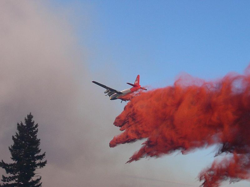
Multi-engine airtankers are comprised of ex-military and retired commercial transport aircraft. They carry from 1800-3,600 gallons of retardant. The speed, range, and retardant delivery capability of these large capacity airtankers make them very effective in both initial attack and large fire support. These airtankers typically make retardant drops from a height of 150 to 200 feet above vegetation and terrain, at airspeeds from 125 to 150 knots. Large fixed-wing airtankers have complex, computer controlled retardant dispersal systems capable of both precise incremental drops and long trailing drops one-fourth of a mile or more in length. Retardant flow rates can also be controlled to vary the retardant coverage level dispersed as required by the intensity of the fire behavior and vegetative fuel type.
  • Helicopters: 


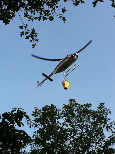
Small, medium and large helicopters carry from 100 to 3,000 gallons of water, foam, or retardant in either buckets slung beneath the aircraft, or in fixed-tanks. Large helitankers can be very cost effective, making rapid multiple drops of 2,000 gallons or more on escaping wildfires by refilling at nearby water sources or at portable retardant bases. The internally mounted retardant tanks for the larger helicopters are also computer controlled, which allow them to drop precise incremental patterns or long trailing lines as required by the fire situation. This is particularly important in urban/ wildland fire interface situations near water sources where they can bring to bear rapid revisit times and precise retardant dropping accuracy. Small and medium helicopters are most effective in the direct support of firefighters on the ground, making precision drops on specific targets.
  • Single Engine Airtankers (SEATS): 


These small, fixed-wing aircraft carry from 400-800 gallons of foam or fire retardant. SEATS can operate from remote airstrips and open fields or closed roads, reloading at portable retardant bases. SEATS are predominantly modified agricultural aircraft; however, the 800-gallon Air Tractor 802 is designed specifically for wildland firefighting. SEATS are most effective in the initial attack of small wildfires within 50 miles of a reload base where turn-around times are short and repeated drops can be made quickly.


And now for some Water Trivia


  • although three percent of the Earth’s water is fresh, only one percent is available for human consumption. In fact, if all the world’s water were fit into a gallon jug, the fresh water available for human use would equal only about one tablespoon.
  • 80 percent of the Earth’s surface is water—it acts as an insulator and helps regulate global temperature.
  • water is the only substance found on Earth naturally in three forms—water can be solid, liquid, or gas.
  • the average person uses well over 133 gallons of water per day.
  • Structural firefighters estimate to protect a Single-family dwelling takes about 5,000 gallons of water.


Trivia Challenge
1. How long can a human survive without water?
a. one day
b. one week
c. one month
d. two months
2. How much does one gallon of water weigh?
a. 3.52 pounds
b. 15.62 pounds
c. 8.34 pounds
d. 11.25 pounds
3. On average, how much water is used to hand wash a sink full of dishes?
a. 10 gallons
b. 20 gallons
c. 30 gallons
d. 50 gallons
4. Approximately how many gallons of water does it take to make four new tires?
a. 2,000
b. 1,000
c. 1,600
d. 150
5. Approximately how many gallons of water does it take to manufacture a new car?
a. 3,000
b. 9,000
c. 20,000
d. 39,000
6. In the United States, from what material were the first water pipes made?
a. metal
b. rubber
c. fire-charred logs
d. clay


Trivia Challenge - Answers
1. b
2. c
3. c
4. b
5. a
6. c

HOW MUCH WATER We talked about various aircraft delivering between 100 and 3,000 gallons of water/retardant but just how much is 1,000 gallons? can you visualize?
Here are a few ways to help...
One acre foot equals 326,700 gallons of water. Picture a football field (approximately one acre) covered one- foot deep in water.
An olympic sized swimming pool holds about 660,000 gallons.


Monday, July 2, 2012

Increase in wildfire activity and an update on Neighbor Mtn and Point 2

In addition to the 2 fires below (the Neighbor Mountain and Point 2) the state had 33 fires for 177 acres over the weekend. Several place received rain withe the storms but many areas received little or no rain, just heavy winds and lightning. 19 of the 33 fires reported were lightning fires.


Neighbor Mountain Fire Incident Update

Monday, July 2, 2012
Information: 404-354-5027 or 404-354-5118
Increased smoke is expected from the Neighbor Mountain Fire.
Overview:
precipitation from the recent storm, but has again begun to increase due to drying conditions. This will result in
increased smoke.
The fire has been burning since June 26, 2012. Fire activity was reduced as a result of
Size:
Shenandoah National Park.
Estimated at 1125 acres as of 4:00 p.m. on 7/01/12, and is still entirely within the boundaries of
Containment:
20% at 4:00 p.m. on 7/01/12. No estimated date of containment.
Fire Conditions:
lines. The forest is a mix of hardwoods, mountain laurel, blueberry and leaf litter.
The fire is burning in steep, rocky terrain and moving slowly downhill toward containment
Today’s Strategy:
Construction of indirect lines is to be completed today.
Crews will continue to build and strengthen lines with direct attack as conditions permit.
Current Resources:
a unified command with the National Park Service and the Virginia Dept. of Forestry to manage the fire.
Resources assigned to the fire include personnel from the National Park Service, USDA Forest Service, US
Fish and Wildlife Service, Virginia Department of Forestry, Mississippi Forestry Commission, and many other
cooperating agencies. There are 237 personnel working on the incident.
The Southern Area Red Team, as a Type 2 incident management team has established
Threats:
No immediate threats to structures.
Fire Closures:
Cutoff, Knob Mountain, Neighbor Mountain, Jeremys Run. Byrd’s Nest #4 Shelter.
The following trails are closed: Appalachian Trail between Elkwallow and Beahms Gap, Knob Mountain
Visitor facilities, Skyline Drive, local highways and amenities all remain open.
Incident Information Sources:
communities – neighbormtnfire@gmail.com. Current information will be available on the park twitter and
facebook sites – http://www.facebook.com/shenandoahnps and
Fire details can also be found on

POINT 2 FIRE

Incident Overview

The Point 2 Wildland Fire is located entirely on national forest lands on Massanutten Mountain between Veach Gap and Sherman Gap in the counties of Warren and Shenandoah. The fire poses a potential threat to homes and private land on the east and west sides. The public is always advised to prepare for a worse case scenario.
Residents should be prepared for smoky or hazy conditions in towns or on road ways. The fire will continue to grow on its own due to hot, dry weather and dry soil conditions.
The terrain is steep, rocky and remote making access to the fire extremely challenging.
Because of the active fire behavior, the following trails are closed until further notice:
The Massanutten National Recreation (#408) from Shawl Gap to Veach Gap. The Tuscarora Trail (#405.1) is closed from Shawl Gap to Panhandle Road (SR 613).
Sherman Gap (#403) and Veach Gap (#484) Trails are also closed. The Little Crease Trail Shelter is also closed to all public use.
The number one priority is public and firefighter safety.
Please use caution with all campfires. Be advised that fireworks are prohibited on national forest lands.

Basic Information

Incident TypeWildfire
CauseLightning
Date of OriginMonday June 25th, 2012 approx. 01:30 PM
LocationGeorge Washington & Jefferson National Forests, Lee Ranger District: Massanutten Mountain
Incident CommanderOscar Montijo/ Jay Collet

Current Situation

Total Personnel218
Size890 acres
Percent Contained30%
Fuels InvolvedPredominately hardwood with some areas of pine and understory brush.
Fire BehaviorBacking and flanking during the burn out operation. Fire continues to burn into the deep duff layer on the dryer ridges.
Significant EventsFire continues to spread east and south along the ridge tops. Began aerial burnout operation on the east side.

Outlook

Planned ActionsPlans for Monday 7/2/12: Firefighters will continue to construct, hold and inprove control lines with bulldozers and hand tools. Assess opportunities to burn out as needed. Complete burn out operations on the east side of the fire. Helicopters will drop water to slow down the fire spread, bring supplies to firefighters and provide aerial ignition for burnout. The public can expect to see smoke on Monday as the fire continues to spread toward control lines and burn out operations are used to burn remaining fuels on the west side. Fire crews will be on the fire Sunday night.
Growth PotentialThere is medium growth potential due to heavy, dry fuels, the steep rugged terrain, difficult access and weather conditions.
Terrain DifficultyTerrain is extremely steep, rocky and rugged making access to the fire challenging for firefighters.
RemarksResidents should be prepared for smoky or hazy conditions in towns and on roadways. Please use caution with all campfires. Be advised that fireworks are prohibited on national forest lands. Homeowners are encouraged to visit www.firewise.org for information on how to make their homes more defensible from wildfires. #1 priority is public and firefighter safety. The fire received 0.2 inches of rain on Friday night from a line of severe thunderstorms that moved through the area last night. There are numerous power outages and trees down in the vicinity of the fire and the ICP.

Current Weather

Wind Conditions17 mph NW
Temperature94 degrees
Humidity29%


Incident Management has set up an email account for communication with thehttp://twitter.com/ShenandoahNPS.www.inciweb.gov, search Neighbor Mountain Fire

Friday, June 29, 2012

Wildfires Continue to burn in Virginia

One can NOT compare the fires that are currently burning in Virginia with those out West. Yes all wildfires are dangerous and any size fire can destroy someones home, injue firefighters and as we see from Colorado can even kill.
Our hearts and prayers go out to all those being impacted by wildfires out west while also doing all we can right here "at home in Virginia".


Two wildfires in western Virginia on Thursday worried some residents when the scent of smoke drifted as far as the District.

According to officials, the wildfires are both burning on federal land, one in the Shenandoah National Park and the other in George Washington & Jefferson National Forests. Trails in both parks were closed because of the fire.

By 6 p.m. Thursday, the Point 2 Wildfire in the George Washington & Jefferson National Forests was about 353 acres, and only 5 percent contained, a spokesman for the Department of Agriculture Forest Service. It is located on Massanutten Mountain between Sherman Gap and Veach Gap, spanning both Shenandoah and Warren Counties. It was first detected on Monday.

Trails were also closed in the Shenandoah National Park for the Neighbor Mountain Fire.
Agreat story and video can be found at


Cautioned urged for July 4th fireworks

The lack of rainfall especially in South-central Virginia is raising concerns that the use of fireworks during the upcoming Fourth of July holiday could spark fires in tinder-dry fields and woods.

Virginia Department of Forestry officials indicate that it's not just cities and towns' pyrotechnic shows that pose a threat. He says small fireworks, cookouts and bonfires that are popular during the holiday could start fires in the dry conditions that would spread rapidly.

While the dry conditions concern fire officials there are no immediate plans to ban fireworks.

The agency is encouraging people planning holiday celebrations to use fireworks safely. Spokesman Gregg O’Donnell says the wildfire potential exists in areas where consecutive days of hot temperatures have dried out vegetation.

“It has been awhile since our last beneficial rainfall in many areas, and it is slowly drying out,” said John Miller, Virginia Department of Forestry’s Director of Resource Protection. “We want everyone to be safe and legal while using fireworks, or better yet leave the fireworks to professionals.”

The Department of Forestry recommends following these safety tips:

  • Buy from reliable fireworks sellers only use those that are legal for use in Virginia and your locality.
  • To detonate fireworks, find a flat surface, away from buildings, dry leaves and grass.
  • Have water, a rake and shovel on hand in case of a fire.
  • Insist on adult supervision when buying or setting off fireworks.
  • Read and follow label directions, warnings and instructions.
  • Be sure other people are out of range before lighting fireworks.
  • Light only one firework at a time.
  • Never try to re-Iight fireworks that have not detonated.
  • Never give fireworks to small children; even sparklers can cause serious burns.
  • Keep all pets especially dogs away from any fireworks.
Fred X. Turck Assistant Director Resource Protection Division Firewise, Prescribed Fire, Prevention and Education

For more info and some prevention material (coloring sheets and mini posters) visit

Wednesday, June 27, 2012

USFS and NPS fighting wildfires in Virginia

There are 2 significant wildfires currently burning on federal lands in Virginia. The US Forest Service and the National Park Service both have fires they along with help from the Virginia Department of Forestry and local resources.


The Point 2 Wildfire is the USFS Fire, currently at 1,000 acres.


The Point 2 Wildland Fire is located on the Massanutten Mountain between Veach Gap and Sherman Gap in the counties of Warren and Shenandoah.
The public can expect to see smoke for several days due to the dry conditions in the fire location and the lack of predicted precipitation.
The terrain is steep, rocky and remote making access to the fire extremely challenging.
Because of the active fire behavior, the following trails are closed until further notice:
The Massanutten National Recreation (#408) from Shawl Gap to Veach Gap. The Tuscarora Trail (#405.1) is closed from Shawl Gap to Panhandle Road (SR 613).
Sherman Gap (#403) and Veach Gap (#484) Trails are also closed.
The number one priority is public and firefighter safety.
Please use caution with all campfires. Be aware that fireworks are prohibited on national forest lands.


The NPS Fire is called the Neighbor Mtn Fire and is near the star on the map below.
This fire is currently 250 acres in size. This fire is also a possible lightning strike from a storm over the weekend. There are 30 people on the fire now with additional resources being ordered up and will be in place tomorrow. The Virginia Department of Forestry will concentrating suppression efforts along rt 612 where numerous homes and a church is in the area. Currently the fire is approximately 3/4 a mile from these structures but will possibly cover much of that distance up overnight and tomorrow.


Saturday, April 14, 2012

Firefighters about to stick a fork in this one and call it done

The main suppression activity is all but over with HOWEVER firefighters will stay with this fire monitoring and moping up for several days or until significant rain occurs.


Shipwreck FIRE UPDATE

Approximately 4000 acres.  3200 acres on National Forest System Land; 800 acres on private land. Additional and enhanced data resulted in the acreage reduction.

   The fire is estimated as 90% contained.

The following roads are closed until further notice: Cub Run Road (FS Road #65).The public will not be able to access Pitt Springs, Big Mountain Road or Peter Fish Road due to this closure.
The following trails are closed until further notice:
Pitt Spring Lookout #584, Massanutten Mountain South #416 (beginning at Pitt Springs and extending South), Fridley Gap #419, Second Mountain #580 (including Boone Run Shelter, Martin Bottom #579, and Morgan Run #583.

The voluntary evacuation for the Shipwreck Farms Area has been lifted.  All residents are permitted to return to their property.


Firefighters will continue mopping up and patrolling the area. Some backfiring operations (burning out unburned areas within the constructed fire lines) will be performed as needed.


Thursday, April 12, 2012

Easter Complex and Shipwereck Wildfire Update


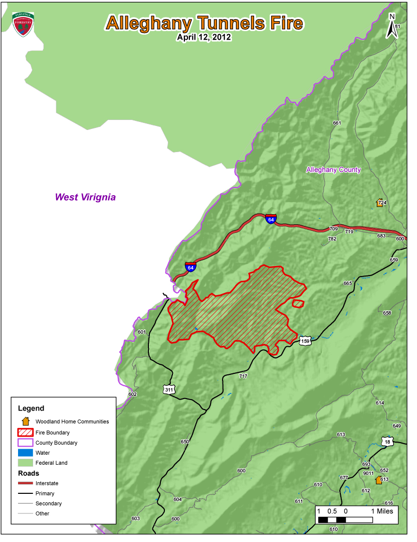
Maps produced by the Virginia Department of Forestry used to help evaluate various challanges with an event such as this. One of those challanges is projecting the wildfires growth potential and its current and future impact of people, homes, businesses and resources in the Wildland Urban Interface.


Fire Information Number for overall fire situation and public inquiries : 
Marq Webb (404) 354-6005 or Michael Williams (540) 525-1539
Fire Information Email-  eastercomplex2012@gmail.com
Incident Management Team is based at the Buena Vista Work Center.

Six fires have burned 20,288 acres.
Over 360 people are assigned to these fires from 23 states including AL, AR, AZ, CO, FL, GA, ID, KY, LA, MI, MN, MS, MT, NC, NM, OK, OR, SC, TN, TX, UT, VA, & WV.


Lee RD:
Wolf Gap Fire (4/12/2012 @ 5:00 p.m.)
PIO- Stephanie Bushong (540) 984-4101. 
Location- Hardy Co. West Virginia and Shenandoah Co. VA
Total Acres: 650 acres primarily on national forest in the Wolf Gap area.
Many road and trail closures- please see official update for details.
Firefighters are working to protect Wolf Gap Campground.
Fire was detected Sunday afternoon 4/8/12.  Cause is undetermined. 
Total Personnel Assigned:  46

Shipwreck Fire (4/12/2012 @ 3:30 p.m.)
PIO- Cindy Frenzel (540) 333-3784
Location- Fire is west of the town of Shenandoah on the Page/Rockingham County Line, east of Harrisonburg. 
Total Acres: 5,971 acres.
Fire was detected on 4/8/12; Fire cause is under investigation.


James River RD:
Alleghany Tunnels Fire (4/12/2012 @ 5:00 p.m.)
PIO’s Alan Craft and Karen Grubbs (540) 962-2214
Location- The Alleghany Tunnels Fire is burning in a remote location 10 miles west of Covington, Alleghany County.  Fire is in the Dunlap Creek drainage of western Alleghany County.
Total acres: 7,656
Forest Roads 69 and 345 are closed.
Smoke visible on I64, SR 311 and SR 59. 
Fire reported 4/7/2012 and cause is undetermined.
Total Personnel Assigned:  56

Rich Hole Fire (4/12/2012 @ 5:00 p.m.)
PIO’s Alan Craft and Karen Grubbs (540) 962-2214
Location- 17 miles east of Covington in the Simpson Creek drainage of eastern Alleghany County and western Rockbridge County.  Estimated 80% of fire is burning in the Rich Hole Wilderness.  Fire is burning on private land and national forest.
Total acres:  3,669
SR 60 (between I-64 Exit 35 and 43)
Fire reported 4/9/2012 at 7:00 p.m. and cause is under investigation.
Total Personnel Assigned: 180

Eastern Divide RD:
Barbours Creek Fire (4/12/2012 @ 5:00 p.m.)
PIO: Barb Walker @ New Castle Work Station (540) 864-5195
Location- Potts Mountain along the Craig/Alleghany Line, 15 miles north of New Castle.  The fire is in Barbours Creek Wilderness and extends into Alleghany and Craig counties.
Total Acres:  2,685 acres
The four residences located northeast of the fire have been secured.  Residences on the northwest corner are the priority today.
Potts Mountain Jeep Trail  and Pines Campground are closed.  Please use caution when driving Barbours Creek Road (SR 617).
Fire was reported on 4/7/2012; cause is undetermined.
Total Personnel Assigned: 82 firefighters plus support staff

Glenwood & Pedlar Ranger Districts:
Cove Mountain Fire (4/12/2012 @ 5:00 p.m.)
PIO- JoBeth Brown (540) 265-5102
57 acres burning in remote area near Arcadia in Botetourt County.
The AT was closed from Saturday morning until Monday morning.  The fire did not reach the trail.
No structures threatened, no roads/trails closed.
Possible smoke visible from I-81
Total Personnel Assigned:  19


News Release
For Immediate Release                                                                                      April 12, 2012
Contact: John Campbell 434.220.9070 or 434.989.0665                                        VDOF 12035

Wildfires Burning on 19,717 Acres in Virginia

Five large wildfires and several small ones are burning more than 19,700 acres across the Commonwealth today.  While most of the large fires are on National Forest System land, the Virginia Department of Forestry, USFS, National Park Service along with numerous volunteer fire departments are out in force battling the blazes to protect lives and property.  They are being aided by federal resources from 22 other states (Alabama, Arkansas, Arizona, Colorado, Florida, Georgia, Idaho, Kentucky, Louisiana, Michigan, Minnesota, Mississippi, Montana, North Carolina, New Mexico, Oklahoma, Oregon, South Carolina, Tennessee, Texas, Utah and West Virginia).

Several Virginia state agencies, including the Departments of Emergency Management, State Police, Transportation and Fire Programs, continue to support the efforts. 

A combination of high winds, low humidity and no precipitation enabled the wildfires to grow and spread quickly.  Many of the fires are on steep, rocky terrain making it difficult for firefighters to reach the flames.

The Shipwreck Fire in Page County has already burned more than 5,000 acres and spans more than 5.5 miles in length – nearly the entire length of First Mountain.  Firefighters working this wildland fire have protected more than 125 homes and other structures thus far.  Several roads and trails are closed.  The cause of the fire is under investigation.    
Ten structures are threatened in the Barbours Creek Fire burning in Alleghany and Craig counties.  More than 2,685 acres have burned thus far, and the fire is 30 percent contained.

The Alleghany Tunnels Fire is burning in a remote location 10 miles west of Covington in Alleghany County.  A total of 7,656 acres have burned, and Forest Roads 69 and 345 are closed.  Smoke is visible on I-64, SR 311 and SR 59.  The fire was reported Saturday and cause has not been determined.  Ten structures have been protected.
The Wolf Gap Fire in Shenandoah County has burned approximately 650 acres primarily on national forest in the Wolf Gap area.  Numerous roads and trails have been closed.  Firefighters are working to protect the Wolf Gap Campground.  Driving visibility in area is limited due to smoke.  The fire was detected Sunday afternoon and the cause is undetermined. 
The Rich Hole Fire (17 miles east of Covington) has burned 3,669 acres and is threatening 10 structures.   Approximately 80 percent of the fire is burning in the Rich Hole Wilderness Area.  The fire is burning on private land and National Forest System land.  The fire was reported Monday at 7 p.m. and the cause is under investigation.
Several smaller fires are burning in several counties across Virginia.  The statewide 4 p.m. Burn Law – which restricts burning until after 4 p.m. each day – is in effect until April 30th.  Several counties, including Caroline, Highland and Rockbridge, have enacted 24-hour burn bans that remain in effect until further notice.  Forestry officials are asking all Virginians not to burn for the next several days and to keep their cigarette butts in their vehicles.

The Virginia Department of Forestry protects and develops healthy, sustainable forest resources for Virginians.  Headquartered in Charlottesville, the Agency has forestry staff members assigned to every county to provide citizen service and public safety protection across the Commonwealth.  VDOF is an equal opportunity provider.
With nearly 16 million acres of forestland and more than 144,000 Virginians employed in forestry, forest products and related industries, Virginia forests provide more than $27.5 Billion annually in benefits to the Commonwealth. 
-end-