Updated at 4:33 p.m. MT, April 11, 2012; original article: 10:54 a.m. MT
Interstate 64 in western Virginia was closed in two places for 20 hours due to wildfires on Tuesday and Wednesday. It reopened around 2 p.m. EDT on Wednesday. Large fires are burning in the counties of Alleghany, Craig, Bath, Rickbridge, Page, Rockhingham, Shenandoah, and Stafford. Just across the state line in West Virginia there are other large fires in Greenbrier and Pocahontas counties.
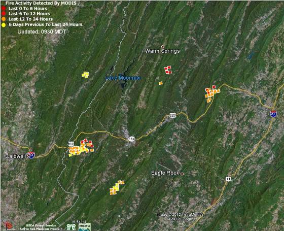
A heat-detecting satellite produced the data on the map above that shows the Virginia fires in the counties of Alleghany, Craig, Bath, and Rockbridge, as well as one fire in West Virginia. The white line running generally north and south is the state line between West Virginia and Virginia.
Mike Quesinberry’s Southern Area Blue Type 1 Incident Management Team is managing five fires that make up the Easter Complex north of Roanoke. Three of those fires are Barbours Creek (1,200 a.), Shipwreck (4,750 a.), and Alleghany Tunnels (6,000 a.). The Shipwreck fire in Page and Rockingham counties is just west of Shenandoah, Virginia. On Tuesday the weather was fairly conducive to fire spread. The relative humidity dropped to 8 percent but the wind speed was 2 to 5 MPH with gusts at 8 to 15. The temperature Tuesday night dropped into the mid-30s, and as of 6:07 p.m. EDT on Wednesday at the Craig Valley weather station it was 45 degrees, the RH was 34%, and the wind was northwest at 3 mph.

No comments:
Post a Comment