Search This Blog

Sunday, August 28, 2011

Hurricane IRENE, VEOC and the bunker

The Virginia Department of Forestry and Fire Programs are working local requests with the local EOC as well as staffing the VEOC (Virginia Emergency Operations Center) at the ESF 4.  Forestry has nearly 50 employees directly involved with the incident responding to numerous requests for assistance. The Dept of Fire Programs is also responding to requests for support from various local fire departments.
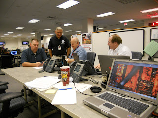
Many times there are plenty of pictures of field operations and I am sure this incident will not be different. When we start getting in some I will post those. But below are several pictures from the "inside" behind the scenes work at the "bunker"


From left to right Don Hansen (DFP). a FEMA rep, Billy Shelton (Executive Director Dept of Fire Program's, Dave Jolly (DFP)

Russ Chandler (VDFP), Steve Grainer (VDFP) and Matt Poirot (VDOF)

Michael Cline (State VDEM Coordinator, Gov Bob McDonnell)

Steve Grainer (VDFP)


John Miller (Director Resource Protection Division VDOF


Michael Cline and Governor McDonnell prepare for news conference.

Fred X Turck (VDOF)

Friday, August 26, 2011

picture from 5 PM TODAY

only 5 min old

Hurricane Irene

Unless you have been living under a rock you should know a major storm named Irene is bearing down in VA and the NE.
A great web site to go to for info is http://www.vaemergency.com/ and www.weather.gov/akq

Here are a few images and info
The following Situation Report that shows evacuations are for low lying areas in those jurisdictions at this time.


Residents and travelers should be aware that a number of bridges in the Northern Neck and Middle Peninsula area may temporarily close to vehicular traffic this weekend during periods of high wind expected to accompany Hurricane Irene.

Signs and barricades are being placed into position near bridges that may close as weather conditions change by the Virginia Department of Transportation (VDOT). VDOT personnel will test wind speeds on these structures throughout the period of severe weather. When bridges are no longer safe for the motoring public, the bridges will close to vehicular traffic.

Motorists are advised to follow the direction on signs and barricades, as the bridges are closed for the protection and safety of travelers.

Bridges will be re-opened by VDOT personnel when crossings are once again safe for travel.
Bridge closings and re-openings will be communicated through local media outlets and www.511virginia.org, VDOT’s 24-hour travel information website, or by calling 511 from any telephone in Virginia.
The following bridges may close this weekend:

Coleman Bridge (Route 17), Gloucester County and York County
• This bridge will close to vehicular traffic when sustained wind speed reaches 45 mph.

Harry W. Nice Bridge (Route 301), King George County
• This bridge is under the authority of the Maryland Transportation Authority. Any closure and re-opening of this bridge will be reported on 511Virginia.

Lord Delaware Bridge (Route 33), King & Queen County and West Point
• This bridge will close to vehicular traffic when sustained wind speed reaches 45 mph.

Lord Eltham Bridge (Route 33), New Kent County and West Point
• This bridge will close to vehicular traffic when sustained wind speed reaches 45 mph.

Robert O. Norris Bridge (Route 3), Lancaster and Middlesex County
• This bridge will close to vehicular traffic when sustained wind speed reaches 45 mph.
• When sustained wind speed reaches 30 mph, permanent electronic message boards at the bridge will communicate a high wind advisory.

Bridges in the Fredericksburg area, Northern Neck and Middle Peninsula may close due to other hazards, such as debris, downed power lines or flooding. All road and structure closings will be reported on 511Virginia.
A mobile version of the 511Virginia website, designed for handheld devices, is available at mobile511virginia.org. Remember to pull over when using your mobile phone or have another passenger use the device. Don’t drive distracted.
Information available on 511Virginia is also communicated through VDOT’s Twitter accounts, targeted for different parts of Virginia and specific interstate corridors. Visit www.VirginiaDOT.org to see a list of VDOT’s Twitter accounts and how to subscribe.
VDOT’s 14-county Fredericksburg District includes the counties of Caroline, King George, Spotsylvania and Stafford in the Fredericksburg area; Northumberland, Richmond, Lancaster and Westmoreland counties in the Northern Neck; Essex, Gloucester, King & Queen, King William, Mathews and Middlesex counties in the Middle Peninsula.


Resources are being staged all up the coast. $ 20 person saw crews and an overhead team are headding to Mass and a type 1 overhead team is being staged at JFK.


ESF 4    12/24/36 hour report
Forestry
            12 hour (1900 8.26.2011 to 0700 8.27.2011)
                        It is anticipated that tropical force wind will begin to impact our Eastern Region during this time. Forestry has 3 chainsaw strike teams (total of 30 sawyers) on call and available to respond to debris removal as necessary. For minor issues or limited needs local forestry folks will work with local VDOT or VSP requests, focusing on primary evacuation routes out of Hampton ie Route 64. Once the need gets beyond local or the capability of the locals’ forestry will deploy other resources as necessary. Dept of Forestry will NOT stage any of the Saw Strike Teams within the “impact area”. Once safety issues can be assessed resources will be deployed.
A critical need will be for these saw crews is support from VDOT with rubber tire loaders or other equipment that can aid in the movement of the debris off the road surface.
            24 hour (0700 8.27.2011 to 1900 8.27.2011)
                        Forestry does not anticipate any additional needs beyond those mentioned previously. Our Saw Crews and personnel are prepared to be self sufficient for the initial response period. This period will be primarily a time to secure agency and personal property focusing on public and personnel safety.

            36 hour (1900 8.27.2011 to 0700 8.28.2011)
                        It is anticipated that this will begin the primary response period. Again no significant needs beyond those previously mentioned. Toward the end of the time and looking forward it is anticipated that fuel, equipment, food/water for the emergency response personnel and other logistical needs will be required if not available from local businesses.
If the storm has completely cleared the state at this time, plans are for the Dept of Forestry to make an aerial flight to assess timber resource damage in coordination with the USFS.

Continuing efforts:
            The EOC will continue to be supported at the ESF 4 desk, the JIC and GIS support as required.

Fire Programs
            12 hour (1900 8.26.2011 to 0700 8.27.2011)
                        It is anticipated that tropical force wind will begin to impact our Division 5 area during this time. The Division Chief has communicated with the Fire and EMS agencies within the division to offer up assistance as needed.  In addition, the agency has prepared the sixty plus support trailers and staged them in the Glen Allen area for deployment.  The Mobile Incident Management personnel from the agency have been placed on standby, if needed.
                        The agency is coordinating with the ESF-9 Technical Rescue Team resources to ensure the availability of those teams outside the affected areas.  We have prepared to provide communications for each of the Division TRT teams should it become necessary.

            24 hour (0700 8.27.2011 to 1900 8.27.2011)
                        We will continue to support both the state and locality request for resources but do not anticipate additional needs beyond what has been previously stated.

            36 hour (1900 8.27.2011 to 0700 8.28.2011)
                        We anticipate the need for potential request for both incident management assistance as well as TRT response for post incident assistance.  The agency will continue to monitor those requests and communicate with the localities as well as the state resources.

Continuing efforts:
            The EOC will continue to be supported at the ESF 4, ESF 7 and ESF 9 positions as needed.


Wednesday, August 24, 2011

Quake hits VA and the DOF HQ office buliding

No damage around our headquarters office here in Charlottsville but the quake sure rattled windows, knoced a few items of shelves and rattled a few folks.

Below is some of the better info I found online. this was from all places a weather site in Ireland (its  small world). Also there is a very good video.


 Buidings a even some trees were shaken and toppled
One of the strongest earthquakes to strike the U.S. East Coast in decades rocked buildings as far as North Carolina and Canada on early Tuesday afternoon, seismologists said, causing damage to buildings and a number of injuries. 
The 5.8-magnitude earthquake at 1.51 p.m. local time (1751 GMT) was centered about 5 miles (8 kilometers) south-southwest of Mineral, a small town in Louisa County in Virginia. It struck about 3.7 miles (6 kilometer) deep, making it a very shallow earthquake and also the most powerful earthquake in the State’s history, according to the United States Geological Survey (USGS).  The quake was followed early Wednesday by two aftershocks, measuring 4.2 and 3.0 magnitude on the Richter Scale


The USGS said the earthquake occurred as reverse faulting on a north or northeast-striking plane within a previously recognized seismic zone, the “Central Virginia Seismic Zone.”
The Central Virginia Seismic Zone has produced small and moderate earthquakes since at least the 18th century. The previous largest historical shock from the Central Virginia Seismic Zone occurred in 1875. The 1875 shock occurred before the invention of effective seismographs, but the felt area of the shock suggests that it had a magnitude of about 4.8. The 1875 earthquake shook bricks from chimneys, broke plaster and windows, and overturned furniture at several locations. A magnitude 4.5 earthquake on 2003, December 9, also produced minor damage.

The extent of the damage near the epicenter of the earthquake was not immediately clear, and Virginia Governor Bob McDonnell said all resources of the state have been put on alert to assist in any way necessary. “All indications are that emergency response plans and orderly evacuations have gone well today, and I thank all involved,” he said.
Photos and videos uploaded to social networking websites showed damage to some buildings. A video uploaded to YouTube showed debris which crushed destroyed several cars in Tyson’s Corner, a unincorporated census-designated place in Fairfax County, Virginia.
At Louisa High School, not far from the epicenter, six students and one staff member were injured. One of them, a teacher, suffered minor injuries when a bookcase toppled over onto her. It was not immediately clear how the students were injured.
At the North Anna nuclear power plant in central Virginia, officials declared an Alert, which is the second-lowest of the four emergency classifications. The alert was declared after the plant lost electricity from the grid following the earthquake, but onsite diesel generators and the plant’s safety systems were operating normally.
At the Surry Nuclear Power Plant, plant officials declared an Unusual Event, which indicates a potential decrease in plant safety but is lower than an Alert.
WASHINGTON, D.C.
Most buildings in downtown Washington, D.C. were immediately evacuated after the earthquake, including the White House, the Pentagon, the U.S. Capitol, and other government buildings. Several people were injured.
Pete Piringer, a spokesman for the D.C. Fire and Emergency Medical Services (EMS), said the most significant damage was reported at the Ecuadorian Embassy, Bell Multicultural School, and several other buildings. “Most of those have significant cracks in the building, chimneys fallen down in the street, things of that nature,” the spokesman said.
“As you might imagine, our crews are very busy but those who are not on call are out in various neighborhoods doing some assessments,” Piringer said. “Checking for structural damage, of course our primary focus will be hospitals, senior centers, schools, buildings of that nature will have the priority, and they are reporting some damage to some of those buildings.”
NEW YORK
In the state of New York, Governor Andrew Cuomo said there were no reports of damage to buildings, bridges, roads, power grids, the Indian Point nuclear power plant, or other infrastructure. “The State Office of Emergency Management continues to monitor effects in New York State from the earthquake,” he said.
In New York City, scores of buildings were also evacuated, including City Hall and the 26-story federal courthouse which is located in lower Manhattan. “Shortly before 2:00 PM, we evacuated City Hall briefly, but quickly returned to work,” Mayor Michael Bloomberg said.
Bloomberg said the earthquake was felt across the city’s five boroughs. “I’ve spoken with our Police and Fire Commissioners, and we’ve activated the Office of Emergency Management’s Situation Room and spoken to other city agencies, including the Department of Buildings. Thankfully, there are no reports of significant damage or injuries in New York City at this time,” he added.
Scott Vanderhoef, County Executive of Rockland County, where the Indian Point nuclear power plant is located, said the earthquake was felt at several locations around the plant, but not inside the control room. “Both units are operating at full power. There are no issues affecting plant operation. Both units have entered the procedure for responding to a seismic event and are checking equipment around the plant,” he said.
Vanderhoef added that there were also no reports of damage elsewhere in the county.
MASSACHUSETTS
The earthquake was also felt on the island of Martha’s Vineyard, located off the coast of Massachusetts, where U.S. President Barack Obama is for his annual vacation. “The president didn’t feel the earthquake today,” White House Principal Deputy Press Secretary Josh Earnest said.
Less than an hour after the earthquake, Obama held a conference call with a number of senior government officials to discuss the event. “The President was told that there are no initial reports of major infrastructure damage, including at airports and nuclear facilities and that there were currently no requests for assistance. The President asked for regular updates on the situation,” Earnest said.
PENNSYLVANIA
Shaking could also be felt in large parts of Pennsylvania, and Pennsylvania Department of Transportation bridge inspectors were doing precautionary inspections of bridges. “We have no reason to believe the Virginia earthquake caused major damage to any state roadways or bridges,” said Scott Christie, the Department’s Deputy Secretary for Highway Administration.
The department said it was first inspecting bridges which are at least 200-feet (60-meter) long or 60 feet (18 meters) high. Inspections would continue throughout the evening and on Wednesday.
In Berks County, however, police closed the Penn Street Bridge in Reading after noticing cracks in the pavement on the bridge approach but the cracks may have been there before the earthquake. “PennDOT inspectors will thoroughly assess the bridge to make sure it was not damaged,” the department said.
Unusual Events were declared at the Peach Bottom Nuclear Generating Station, the Three Mile Island Nuclear Generating Station, the Susquehanna Steam Electric Station, and the Limerick Nuclear Power Plant.
WEST VIRGINIA
West Virginia Governor Earl Ray Tomblin said he was ‘surprised and immediately concerned’ about the earthquake. “Within minutes of the event, I directed Homeland Security Director Jimmy Gianato to contact various state agencies, utilities, chemical plants and the U.S. Army Corps of Engineers to assess and make quick determination if any of our citizens or significant infrastructure was in need of assistance,” he said. “Fortunately, there are no reports of any injuries or damage caused by the quake.”
NEW JERSEY
Plant officials declared Unusual Events at the Salem Nuclear Power Plant, the Hope Creek Nuclear Generating Station, and the Oyster Creek Nuclear Generating Station.
MARYLAND
An Unusual Event was declared at the Calvert Cliffs Nuclear Power Plant near Lusby in Calvert County.
NORTH CAROLINA
An Unusual Event was declared at Shearon Harris Nuclear Power Plant in New Hill.
MICHIGAN
An Unusual Event was declared at Donald C. Cook Nuclear Generating Station north of Bridgman.
The earthquake in Virginia was the state’s largest in intensity since a 5.9-magnitude earthquake struck Giles County in 1897. It also came just hours after a 5.3-magnitude earthquake struck 4 miles (6 kilometers) south of Segundo, a small unincorporated community in Las Animas County, Colorado. There was some damage, and the USGS said it was the strongest earthquake to hit the state since a 5.3-magnitude earthquake was recorded near Denver on August 9, 1967.
MORE ABOUT THE EAST COAST’S SEISMIC PAST
Previous seismicity in the Central Virginia Seismic Zone has not been causally associated with mapped geologic faults. Previous, smaller, instrumentally recorded earthquakes from the Central Virginia Seismic Zone have had shallow focal depths (average depth about 8 km). They have had diverse focal mechanisms and have occurred over an area with length and width of about 120 km, rather than being aligned in a pattern that might suggest that they occurred on a single causative fault. Individual earthquakes within the Central Virginia Seismic Zone occur as the result of slip on faults that are much smaller than the overall dimensions of the zone. The dimensions of the individual fault that produced the 2011 August 23 earthquake will not be known until longer-term studies are done, but other earthquakes of similar magnitude typically involve slippage along fault segments that are 5 – 15 km long.
Earthquakes in the central and eastern U.S., although less frequent than in the western U.S., are typically felt over a much broader region. East of the Rockies, an earthquake can be felt over an area as much as ten times larger than a similar magnitude earthquake on the west coast. A magnitude 4.0 eastern U.S. earthquake typically can be felt at many places as far as 100 km (60 mi) from where it occurred, and it infrequently causes damage near its source. A magnitude 5.5 eastern U.S. earthquake usually can be felt as far as 500 km (300 mi) from where it occurred, and sometimes causes damage as far away as 40 km (25 mi).


Tuesday, August 23, 2011

More interesting history of the swamp and surrounding area.


The Dismal Swamp and Lake Drummond, Early recollections Vivid portrayal of Amusing Scenes  by Robert Arnold 1888
 

CHAPTER IX.SUFFOLK AND EARLY DAYS.
I will take the above railroad and return to Suffolk, when I will say something of my early recollections of that place. It was in the year 1830 that my father, with his family, moved to it. I was quite small at that time, but I recollect the time well. Suffolk was then a small village, situated on the Nansemond River, with a population of about five hundred, and increased very slowly in population until after the surrender, which was in April, 1865. Since that it has increased very rapidly in population and growth. It was in Suffolk that Henry Herman commenced his business career; moved to Norfolk in 1832; and became one of her successful merchants. At his death his remains were brought to Suffolk, and now quietly rest in Cedar Hill Cemetery. I could mention many instances of successful business men of that town were it necessary. I will now write of things of more recent date--something within the recollection of many persons yet living. It will be recollected that a fire broke out in June, 1837, that destroyed the lower part of the town. There were no engines in the place and the flames raged with great fury. The Allen residence, at Rose Hill, about one half mile distant, was set on fire several times by the flying debris, and it was with difficulty that the house was saved. It was at Rose Hill that a large mercantile business was carried on, and no doubt a large quantity of juniper lumber was shipped from that point belonging to private individuals. A wharf was built at the mouth of Shingle creek (I imagine long before the Jericho canal was dug), and large quantities of lumber was hauled to it by persons living on the edge of the Dismal Swamp. I knew of several persons who owned large juniper glades on the edge of Dismal Swamp one in particular. His name was Thomas Swepston and lived not far from Suffolk, on the line of the Seaboard railroad, which divides his farm. He was agent of the Dismal Swamp Land Company for several years, and may have been the first after the Jericho canal was opened. The last agent, of whom I have any knowledge, was W. S. Riddick, Esq., who died several years ago. The last inspector of lumber was J. E. Bonnewell, of whom it is my pleasure to notice particularly. Perhaps no man was more generally known and respected in Suffolk than he. He was a true friend, benevolent and kind, never refusing to bestow charity when called upon. He succeeded Mr. Joseph Hill as inspector for the company, which office he held until his death. It was during his term of office that it was made so pleasant to visit the Lake. By giving timely notice he would always give the parties the best boats and the most trusty hands as drivers, and would always be present when the boat left its landing and when it returned, and was anxious to know if any mishaps had occurred to any of the party. And if it should be reported that some lady had fallen into the canal, he would always very politely ask that she be carried into his house to be made more comfortable. Capt. Babel Ions, of Philadelphia, was his bosom friend. When the Captain was in Suffolk, they could always be found together. They both have passed away, and a generous people will do justice to their memory. Captain Connewell died leaving a rich heritage behind--a name that will live as long as it is called. But few have lived and died who was so much beloved and respected as he. He was proud but not haughty, and flexible to kind impulses. He was the soul of honor, and no one can say that he even failed to accord to everyone their just dues. I knew him from my boyhood up and never knew a better man. He left an interesting family--Mrs. H. R. Culley being his eldest daughter. I could write many noble traits in the character of that good man, but it is not necessary. There are but few of his compeers now living, and soon they will all have passed away. Such is the march of time.

Nothing very important transpired in Suffolk from 1837 until after the close of the late war, when she awoke from her slumbering condition; her watchword being progress. She brushed the dust from her eyes, and her advancement in every branch of industry can be seen in her rapid growth. She stands second to no town in a commercial point of view. Her manufacturing interests are considerable, and being a railroad centre she must prosper and grow. The disastrous fire which occurred June 7th, 1885, impeded business for a few months, but our men of capital at once commenced to repair the breach, and she is again on the road to fame and wealth. And it is to the Suffolk and Carolina or Short Line railroad that Suffolk is mostly indebted for her present prosperous condition. Penetrating as it does a country that is rich and fertile, she has already felt its influence and it should be fostered as one of the main arteries to her prosperity.
The Gay Manufacturing Company, before noticed, is perhaps the most gigantic enterprise ever projected at Suffolk. It has extended its operations as far South as Chowan County, N. C., and the amount of capital invested is no doubt the largest investment of its kind in Virginia, if not in the entire South. It has made large purchases of land in and around Suffolk and has bought all the timbered lands on the Suffolk and Carolina Short Line or Grand Trunk railroad, giving employment to hundreds of hands, at fair wages, that would otherwise eke out a miserable existence. It also enables the landowners, from the sale of their timber, to free themselves from debt and otherwise improve their condition. Under the direction of President W. N. Camp, it has had erected near Suffolk, on the line of the S. & C. R. R., one of the most extensive saw mills in Eastern Virginia, and with the aid of the Atlantic and Danville railroad penetrating the primeval forests of Southampton, Greensville and other counties of Virginia. Millions of logs will be brought on that road and manufactured for shipment to Northern markets. The company consists principally of Baltimoreans, who will reap a harvest commensurate with the capital invested. And in many instances it is owing to the mature judgment of President Camp that the efforts to establish this great enterprise has been crowned with such signal success. The advantages this company possesses, by its intimate connections with the S. & C. R. R., and A. & D. R. R., cannot be estimated, but it can be truly said that their intimate and close relations with each other, while each is a separate and distinct corporation, forms one of the grandest and far-reaching enterprises of its kind in the South.
The Gay Manufacturing Company consists of William N. Camp, president; Charles F. Pitt, Jr., Chauncy Brooks, S. P. Ryland, John M. Denison and William N. Camp, directors; George L. Barton, treasurer; Charles F. Pitt, Jr., secretary.
The A. & D. R. R. has made great internal improvement under the management of Major Charles B. Peck, of New York, and has progressed more rapidly than any road of which we have any knowledge. Its starting point is at West Norfolk, on the Elizabeth river, at the mouth of its western branch, the great trucking region of the State of Virginia which will supply it with thousands of dollars worth of freight annually. It runs diagonally across the Norfolk and Western and Seaboard and Roanoke, railroads, both of which have already felt its effects, and when it shall have reached Danville the Richmond and Danville will then feel its withering influence, for this being the shortest and most speedy route to deep water, in one of the finest harbors in the world, it is natural that all produce will seek such a route and such a favorable shipping point.

An artist rendition (above) and an actual picture (below) of the Halfway House (Lake Drummond Hotel), built in 1829, which was located originally on the NC/VA line.   The line was later moved 555 ft to the south.  It is rumored to be a site where one could “step over the line” and immediately be out of reach of local law.


Chronology of the Great Dismal Swamp

1665    Lake discovered by William Drummond
1728     Dismal Swamp Canal proposed by William Byrd
1763     Lake Drummond charted by George Washington's surveyor
1764     Dismal swamp Land Company chartered
1787     Dismal Swamp Canal authorized by Virginia Legislature
1790     Dismal Swamp Canal authorized by North Carolina Legislature
1793     Work on the Dismal Swamp Canal began
1802     William Farange builds first hostelry in Camden County, N.C.
1803     Thomas Moore wrote "THE LAKE OF THE DISMAL SWAMP"
1805     Dismal Swamp Canal began limited through navigation for flat boats
1810     Jericho Canal completed
1812     Feeder Ditch completed
1814     First recorded passage of a vessel other than a shingle flat
1818     President James Monroe visited the Dismal Swamp
1819     First Lottery held to raise funds for improving the Canal
1820     Second Lottery held
1822     Cross Canal completed
1823     First passage of completely loaded schooner "Rebecca Edwards"
1825     Erie Canal completed
1826     U.S.Congress purchased 600 shares of Dismal Swamp Company
1826     Dismal Swamp Canal enlarged as a shoal draft ship canal
1829     Third Lottery held
1829     Lake Drummond Hotel built
1829     President Andrew Jackson visited the Dismal Swamp Canal
1829     Federal Government purchased 200 additional shares of stock
1830     "Lady of the Lake" first steamer designed to ply the canal
1830     North West Canal completed
1867     State of Virginia's 600 share holdings sold at auction
1871     North West Canal closed by dam built to conserve water
1878     Congress sold its shares in the Dismal Swamp Canal
1890     Emma K - Dismal Swamp's favorite vessel - was built
1899     Dismal Swamp Canal enlarged in substantially its present form
1929     United States Government purchased the Lake Drummond Company
1974     Great Dismal Swamp National Wildlife Refuge created

Tuesday, August 16, 2011

A look back in pictures of Dismal Swamp Fires 80 +/- years ago

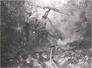
This posting will be mostly historical pictures of days gone by. The Virginia Department (then Division ) of Forestry had wildfire (then forest fire) suppression responsibility in the swamp up till 1975. Then the FWS toomk it over THANK YOU FWS!!!

Site of old skidder setting which was burned to prevent a possible heavy fire when the oncoming Dismal Swamp fire reached the railroad all at once.

October 25, 1930
Burning skidder settings along the railroad. Evinrude pumps in use.


Portion of the western fire line between the Norfolk and Western Railroad and the Five Mile Ditch. October 28, 1930

Preparing to be put into use.  Pacific Type Y portable pump. November 13, 1937.

An Evinrude pump with 1 and ½ miles of hose used to extinguish burning log heaps at skidder setting along the logging railroad.

October 1930
Devastating effects the wildfire on a cutover area west of the Portsmouth Ditch just north of the Big Entry Ditch.


Another trusty Evinrude in action October 26, 1930.

June 1942 Fire along the Feeder Canal. Note original ground level at the gentlemen's chest.

Flood gate on one of the ditches.


Man standing in a water hole dug for water during the October 1930 swamp fire. He is indicating the depth of the peat, 7 to 10 feet in depth.


Water pump used to extinguish ground fire at the roots of a large twin Red Maple.

October 23, 1930


A large hardwood stump with the peat burned from beneath its roots. Located along the logging railroad between the Dismal Swamp canal and the Portsmouth Ditch.

An Evinrude pump with 1 and ½ miles of hose used to extinguish burning log heaps at skidder setting along the logging railroad.

Division of Forestry’s   truck #2 being prepared  to respond to a swamp fire.


 Equipment needs for swamp crews.
Below is a poem from 1804.


I hope you enjoyed this look back in time.