Search This Blog

Showing posts with label Page County. Show all posts

Monday, April 16, 2012

Arson Rewards offered and Wildfire Updates, Almost 30,000 acres in VA have burned in last 10 days


Arson Suspected As Cause of Page County and Bath County Wildfires, $2,000 Reward Offered


Wildland fire investigators suspect that the 4,000-acre Shipwreck Fire burning in Page County was ignited by one or more arsonists as was the 125 acre Stuart Fire in Patrick County.   
“The lives and property of residents and firefighters are directly threatened by these suspicious fires,” said John Miller, director of resource protection for the Virginia Department of Forestry.  “When a wildfire is intentionally set, it endangers lives and can cause unbelievable destruction to land, trees and homes,” Miller said.  “In addition, when firefighters are working an arson fire, they and their equipment are not available to suppress other wildland fires.  This depletion of resources puts even more people and their property at risk.”
The Virginia Department of Forestry needs citizens to be vigilant in the fight against arson.  If you see something suspicious, call 911 or in Page County you can call the Page County Crime Solvers Number at 540-743-3272. Call immediately day or night the quicker law enforcement officers can respond the greater the chance to be successful.  Your help may be worth up to $2,000 – the reward offered for information that leads to the conviction of an arsonist.
The lack of rain, low humidity, high winds and mountainous terrain helped the fire spread quickly, and the additional fire starts pose great danger to anyone or anything in their path.
Woods arson is the common term for deliberately burning forests, grasslands or brush without the owner’s permission. The VDOF and other law enforcement officials are concerned with the number and frequency of these dangerous, destructive and senseless criminal acts. Woods arson is a felony in Virginia and, when convicted, the guilty person could serve up to five years in prison, pay a fine of $2,500 and be liable for the cost of suppressing the fire.
If you see any fire where firefighters have not yet arrived on the scene, make note of the following:
  • Location and time of the fire
  • Description of persons observed in the area
  • Description of any vehicles observed and the license plate if possible
  • Any other pertinent information
"We need the public's help in the continuing investigation of the cause of these suspicious fires,”. Your information may be just the piece of the puzzle that helps us put an end to potentially deadly and criminal acts.” 


Summary:  
                        Elevated fire weather conditions continue across Virginia. Virginia Department of Forestry (VDOF) reports 33 fires burned approximately 102 acres on private land. Fifty-one homes/structures were protected and 1 home/structure was damaged from Friday, 13 April, through Sunday, 15 April. Large wildfires on private property and National Forest land:

·         Easter Complex (6 fires managed by U.S. Forest Service Incident Management Team the “Blue Team”)
o   Page County, Shipwreck Fire: acreage burned – 4,000; 100% contained
o   Alleghany/Craig Counties, Barbours Creek Fire: acreage burned – 4,783; 40% contained
o   Shenandoah County, Wolf Gap Fire: acreage burned – 755; 95% contained
o   Alleghany/Rockbridge Counties, Rich Hole Fire: acreage burned – 12,131; 30% containment
o   Alleghany County, Alleghany Tunnel Fire: acreage burned – 11,381; 85% contained
o   Bath County, Porter Mills Fire: acreage burned – 879; 95% contained (assumed management on 15 April)


The following Counties have notified us that they have implemented county wide bans on all open burning that are over and above the stats 4PM burn law. PLEASE check with your county if you are planning any outdoor activity that may involve open burning.

Botetourt County
King George County
Caroline County
Bath County and
Northampton County.


 In addition I know that Douthat State Park has also enacted restrictions on within the boundary of the park that prohibit campfires and the use of any outdoor fires.
From the Park’s web site….Due to extreme fire conditions there is a burn ban within the park. All open fires and charcoal fires are prohibited at this time. Propane is permissible.

Thursday, April 12, 2012

Easter Complex and Shipwereck Wildfire Update


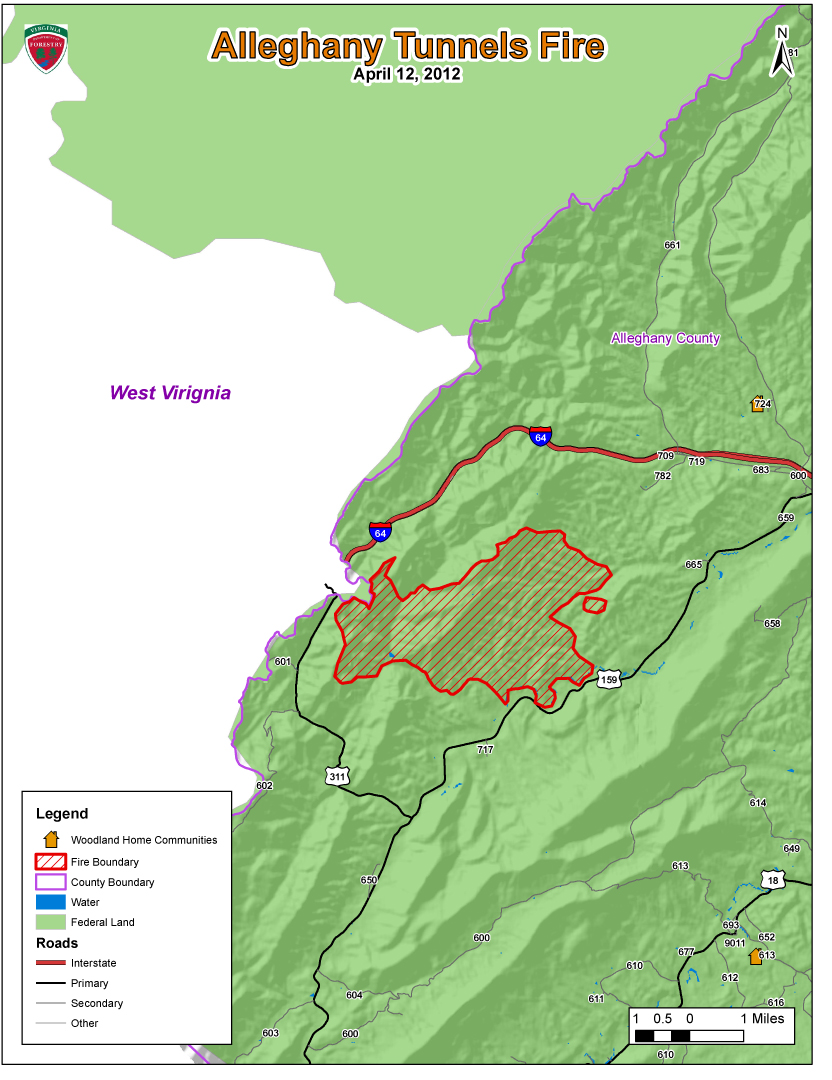
Maps produced by the Virginia Department of Forestry used to help evaluate various challanges with an event such as this. One of those challanges is projecting the wildfires growth potential and its current and future impact of people, homes, businesses and resources in the Wildland Urban Interface.


Fire Information Number for overall fire situation and public inquiries : 
Marq Webb (404) 354-6005 or Michael Williams (540) 525-1539
Fire Information Email-  eastercomplex2012@gmail.com
Incident Management Team is based at the Buena Vista Work Center.

Six fires have burned 20,288 acres.
Over 360 people are assigned to these fires from 23 states including AL, AR, AZ, CO, FL, GA, ID, KY, LA, MI, MN, MS, MT, NC, NM, OK, OR, SC, TN, TX, UT, VA, & WV.


Lee RD:
Wolf Gap Fire (4/12/2012 @ 5:00 p.m.)
PIO- Stephanie Bushong (540) 984-4101. 
Location- Hardy Co. West Virginia and Shenandoah Co. VA
Total Acres: 650 acres primarily on national forest in the Wolf Gap area.
Many road and trail closures- please see official update for details.
Firefighters are working to protect Wolf Gap Campground.
Fire was detected Sunday afternoon 4/8/12.  Cause is undetermined. 
Total Personnel Assigned:  46

Shipwreck Fire (4/12/2012 @ 3:30 p.m.)
PIO- Cindy Frenzel (540) 333-3784
Location- Fire is west of the town of Shenandoah on the Page/Rockingham County Line, east of Harrisonburg. 
Total Acres: 5,971 acres.
Fire was detected on 4/8/12; Fire cause is under investigation.


James River RD:
Alleghany Tunnels Fire (4/12/2012 @ 5:00 p.m.)
PIO’s Alan Craft and Karen Grubbs (540) 962-2214
Location- The Alleghany Tunnels Fire is burning in a remote location 10 miles west of Covington, Alleghany County.  Fire is in the Dunlap Creek drainage of western Alleghany County.
Total acres: 7,656
Forest Roads 69 and 345 are closed.
Smoke visible on I64, SR 311 and SR 59. 
Fire reported 4/7/2012 and cause is undetermined.
Total Personnel Assigned:  56

Rich Hole Fire (4/12/2012 @ 5:00 p.m.)
PIO’s Alan Craft and Karen Grubbs (540) 962-2214
Location- 17 miles east of Covington in the Simpson Creek drainage of eastern Alleghany County and western Rockbridge County.  Estimated 80% of fire is burning in the Rich Hole Wilderness.  Fire is burning on private land and national forest.
Total acres:  3,669
SR 60 (between I-64 Exit 35 and 43)
Fire reported 4/9/2012 at 7:00 p.m. and cause is under investigation.
Total Personnel Assigned: 180

Eastern Divide RD:
Barbours Creek Fire (4/12/2012 @ 5:00 p.m.)
PIO: Barb Walker @ New Castle Work Station (540) 864-5195
Location- Potts Mountain along the Craig/Alleghany Line, 15 miles north of New Castle.  The fire is in Barbours Creek Wilderness and extends into Alleghany and Craig counties.
Total Acres:  2,685 acres
The four residences located northeast of the fire have been secured.  Residences on the northwest corner are the priority today.
Potts Mountain Jeep Trail  and Pines Campground are closed.  Please use caution when driving Barbours Creek Road (SR 617).
Fire was reported on 4/7/2012; cause is undetermined.
Total Personnel Assigned: 82 firefighters plus support staff

Glenwood & Pedlar Ranger Districts:
Cove Mountain Fire (4/12/2012 @ 5:00 p.m.)
PIO- JoBeth Brown (540) 265-5102
57 acres burning in remote area near Arcadia in Botetourt County.
The AT was closed from Saturday morning until Monday morning.  The fire did not reach the trail.
No structures threatened, no roads/trails closed.
Possible smoke visible from I-81
Total Personnel Assigned:  19


News Release
For Immediate Release                                                                                      April 12, 2012
Contact: John Campbell 434.220.9070 or 434.989.0665                                        VDOF 12035

Wildfires Burning on 19,717 Acres in Virginia

Five large wildfires and several small ones are burning more than 19,700 acres across the Commonwealth today.  While most of the large fires are on National Forest System land, the Virginia Department of Forestry, USFS, National Park Service along with numerous volunteer fire departments are out in force battling the blazes to protect lives and property.  They are being aided by federal resources from 22 other states (Alabama, Arkansas, Arizona, Colorado, Florida, Georgia, Idaho, Kentucky, Louisiana, Michigan, Minnesota, Mississippi, Montana, North Carolina, New Mexico, Oklahoma, Oregon, South Carolina, Tennessee, Texas, Utah and West Virginia).

Several Virginia state agencies, including the Departments of Emergency Management, State Police, Transportation and Fire Programs, continue to support the efforts. 

A combination of high winds, low humidity and no precipitation enabled the wildfires to grow and spread quickly.  Many of the fires are on steep, rocky terrain making it difficult for firefighters to reach the flames.

The Shipwreck Fire in Page County has already burned more than 5,000 acres and spans more than 5.5 miles in length – nearly the entire length of First Mountain.  Firefighters working this wildland fire have protected more than 125 homes and other structures thus far.  Several roads and trails are closed.  The cause of the fire is under investigation.    
Ten structures are threatened in the Barbours Creek Fire burning in Alleghany and Craig counties.  More than 2,685 acres have burned thus far, and the fire is 30 percent contained.

The Alleghany Tunnels Fire is burning in a remote location 10 miles west of Covington in Alleghany County.  A total of 7,656 acres have burned, and Forest Roads 69 and 345 are closed.  Smoke is visible on I-64, SR 311 and SR 59.  The fire was reported Saturday and cause has not been determined.  Ten structures have been protected.
The Wolf Gap Fire in Shenandoah County has burned approximately 650 acres primarily on national forest in the Wolf Gap area.  Numerous roads and trails have been closed.  Firefighters are working to protect the Wolf Gap Campground.  Driving visibility in area is limited due to smoke.  The fire was detected Sunday afternoon and the cause is undetermined. 
The Rich Hole Fire (17 miles east of Covington) has burned 3,669 acres and is threatening 10 structures.   Approximately 80 percent of the fire is burning in the Rich Hole Wilderness Area.  The fire is burning on private land and National Forest System land.  The fire was reported Monday at 7 p.m. and the cause is under investigation.
Several smaller fires are burning in several counties across Virginia.  The statewide 4 p.m. Burn Law – which restricts burning until after 4 p.m. each day – is in effect until April 30th.  Several counties, including Caroline, Highland and Rockbridge, have enacted 24-hour burn bans that remain in effect until further notice.  Forestry officials are asking all Virginians not to burn for the next several days and to keep their cigarette butts in their vehicles.

The Virginia Department of Forestry protects and develops healthy, sustainable forest resources for Virginians.  Headquartered in Charlottesville, the Agency has forestry staff members assigned to every county to provide citizen service and public safety protection across the Commonwealth.  VDOF is an equal opportunity provider.
With nearly 16 million acres of forestland and more than 144,000 Virginians employed in forestry, forest products and related industries, Virginia forests provide more than $27.5 Billion annually in benefits to the Commonwealth. 
-end-