Search This Blog

Monday, October 29, 2012

Sandy Talking Points


HURRICANE SANDY
Talking Points, Monday, October 29, 2012, 7 a.m.

Impact to Virginia
·        No storm-related deaths or serious injuries reported.

·        No storm-related traffic fatalities reported.

Potential Impact to Virginia
        Sandy is a large storm that will affect Virginia with sustained winds, rain, storm surge and coastal damage in the eastern regions; significant snowfall expected in the higher elevations of southwest Virginia.

  • Latest National Weather forecast:
·        Southside Hampton Roads: 2-3 inches of additional rain, sustained winds of 30-35 mph and gusts of 50-55 mph
·        Eastern Shore: 4-6 inches of additional rain, sustained winds of 40-45 mph and gusts of 60-65 mph and higher
·        Northern Neck: 3-4 inches of additional rain, sustained winds of 40-50 mph and gusts of 60-70 mph
·        Middle Peninsula: 2-3 inches of additional rain, sustained winds of 35 mph and gusts of 50-60 mph
·        Peninsula: 2 inches of additional rain, sustained winds of 30-35 mph and gusts of 50-55
·        Interstate 95 corridor including Richmond: ½ inch to 3 inches of additional rain, sustained winds of 30-35 mph and gusts of 45-55 mph
·        Southwest Virginia: winter storm warnings for much of this region with snow accumulations and potential for blizzard conditions in far southwest Virginia due to high winds and blowing snow
Power Outages
·        Approximately 3,000 statewide.  Mainly concentrated in pockets along Eastern Shore, Norfolk, Hampton Roads, Middle Peninsula and southside (i.e. Chesapeake, Suffolk, etc.)  Another pocket of outages in Roanoke County.


Governors Actions
·          The governor issued a limited mandatory evacuation order for low-lying areas in coastal Virginia.  This order gives authority to local government officials to determine specific locations to be evacuated and times that evacuations will start, based on best information about the storms impact.
        The governor declared a state of emergency Friday, Oct. 26, at 9:50 a.m. to help quickly get supplies, equipment and staff to those who need it.
Traffic Information
·        DC Metro closed Monday.

·        Amtrak Northeast Corridor Services to include Virginia are cancelled Monday.

·        VDOT reports the following road closures: one primary road (numbered 0-599) and 19 secondaries (numbers 600 and above) are closed as of 7 a.m.

·        The tide gate to the Midtown Tunnel in Hampton Roads has been lowered, and the tunnel is now closed to motorists. 

·        The Hampton Roads Bridge-Tunnel is open.  Crews are in place and are making preparations should the expected high tide require it to close.

·        Jamestown-Scotland Ferry resumed service at 3 a.m., and the Pocahontas will run until further notice.  The ferry departs the Surry dock on the hour and the Jamestown dock on the half hour.

  • Crews in the western region of the state are standing by for snow removal.  The storm is expected to cause cold weather, producing heavy snow fall in the higher elevations of western Virginia.

For a full list of road closures and conditions, click http://www.511virginia.org/mobile/?menu_id=conditions

What to watch out for:
  • If a traffic signal is out, drivers are advised to treat the intersection as a four way stop.
  • Never drive through water flowing across a road. It takes only six to 12 inches of water to float a small vehicle.
  • Never drive around barricades. Remember, the road has been closed for your safety.
  • Slow down when driving through standing water. Driving too fast through water could cause you to lose control and hydroplane.
  • Avoid flood-prone areas, especially along creeks and other low-lying areas. Water in those areas can rise quickly and without warning during heavy rains.
  • In the event of a flash flood warning for your area, seek high ground immediately.
  • Watch for debris on the roadway. If you encounter a downed power line, do not try to move the line. Downed trees may contain power lines. Contact VDOT or Dominion Virginia Power.
Messages to motorists:

  • Limit travel during height of storm.
  • Monitor local weather and traffic reports before getting into the car.
  • Before heading out the door, get the latest road conditions by calling 511, visit www.511virginia.org or download the mobile app from the 511 web site.
  • Use 9-1-1 only in emergencies. Dial #77 on cell phone to report traffic crashes or traffic emergencies to State Police.
  • State law requires headlights to be on when windshield wipers are activated.
  • Motorists must use extreme caution on the road and never attempt to drive through flood waters.
  • Remain alert to avoid fallen trees.
  • Drive free of distractions and always buckle up.

What should residents be doing now?
         Final emergency preparations should be completed now.   
        Stay tuned to local TV and radio stations for instructions and information.  Those in eastern Virginia who live in low-lying areas should be ready to evacuate if told to do so by local officials.
  • 25 shelters have been opened for residents on the Eastern Shore, Northern Neck, Middle Peninsula, and Hampton Roads localities. The best source for local shelter information is local media and local government websites.  As of 6 a.m., Monday, October 29, to include:

Localities with Open Shelters
Accomack County
City of Chesapeake
City of Colonial Heights
City of Hampton
King William County
Lancaster County
Mathews County
New Kent County
City of Newport News
City of Norfolk
Northampton County
Northumberland County
City of Portsmouth
City of Richmond
Surry County
City of Virginia Beach
York County/Poquoson

         If power is out, use flashlights, not candles.
·        Remember Carbon monoxide is a silent killer.  Do not bring generators into the house. Dont use camp stoves and lanterns without ventilation.  Never use stoves for heating.  Any of these can cause deadly buildup of carbon monoxide. If using a space or kerosene heater, practice proper safety procedures.

        Keep your refrigerator and freezer closed as long as possible to maintain the cold temperature.

Numbers to Call for Information
         2-1-1 Virginia is serving as the public inquiry number for Virginia residents.
        5-1-1 is to be used for the latest in road conditions. Only call 9-1-1 in a true emergency.
       #77 on a cell phone to report a traffic crash or traffic emergency
        Residents should call their localitys non-emergency number for updated storm-related and shelter information.  Only call 9-1-1 in a true emergency. 
State and federal preparations

·        State offices in Richmond are closed Monday, October 29, 2012.
·        Federal government in DC is closed Monday, October 29, 2012.
·        The Virginia Emergency Operations Center is coordinating the states response with increased staffing 24 hours a day.
·         Virginia State Police personnel have been pre-positioned on the Eastern Shore to assist localities with traffic and emergency response.  The Virginia State Police Search & Recovery dive teams are standing by on the Eastern Shore, Hampton, Richmond and Northern Virginia. State police are also preparing for response to snow-related traffic and emergencies in western and Southwest Virginia.

         Virginia National Guard personnel have been pre-positioned to the eastern shore and other potentially impacted areas.  Additional personnel are on state active duty.
        Chainsaw crews from the Virginia Department of Forestry are standing by with emergency response personnel to help with debris removal.
        Virginia Department of Transportation crews are ready to clear roads of debris and snow and ensure roads are safe for travel.  Crews will work in 12-hour shifts throughout the storm.
         The Virginia Department of Health is coordinating with hospitals and long-term care facilities to ensure they are prepared for storm impacts. Regional Storm watch officers are tracking and communicating with waterworks across the state.
         Close coordination is under way between the VEOC and Virginias power and telecommunications providers to handle potential disruptions in services.
        The Federal Emergency Management Agency (FEMA) incident management advance team is in the Virginia Emergency Operations Center (VEOC) to assist in coordinating response.
         Representatives from the U.S. Coast Guard and U.S. Department of Defense are in the VEOC to assist in coordinating response.
Resources
         211 Call toll-free for information on many topics related to the storm.
      511 - Call toll-free for the latest in road conditions and closures; or www.511virginia.org 
         vaemergency.gov Go online or on your smart phone for statewide storm updates.
         @vdem Twitter feed for storm updates from the VA Dept. of Emergency Management
         VAemergency Facebook page for the Virginia Department of Emergency Management

10.29 0700 hrs briefing

Most of the activity overnight occured in the tidewater area. Significant inland impacts are expected today.


Weather Forecast:
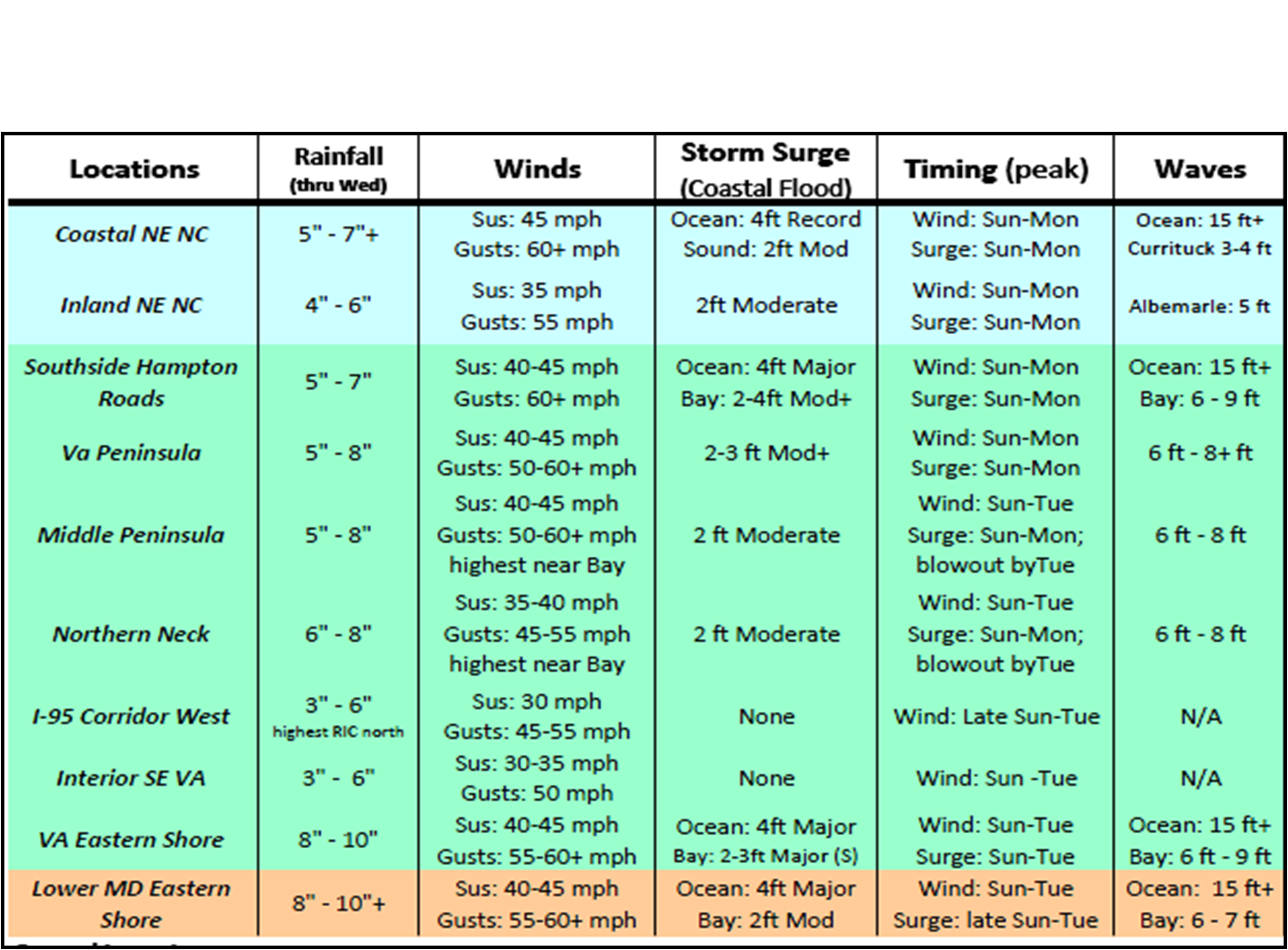
Hurricane Sandy is on northern track due east of Cape Hatteras NC. Sandy has strengthened as expected with winds now at 85 mph as she transitions to a strong Nor’Easter. Moderate to potentially severe tidal flooding is forecast for coastal VA during periods of high tides today.   The moderate to severe tidal flooding along the Eastern Shore is forecast thru Tuesday. 
Coastal Virginia and eastern shore localities remain under a high wind warning until midnight tonight for sustained winds of 35/45 mph and wind gusts to 60 mph.  In general, winds will be less severe further inland, with gusts to 40 to 45 mph expected across much of the Interstate 95 corridor including Richmond, with 35-40 mph gusts west of this region. 
Five to seven (5-7) inches of rain is expected in Hampton Roads and eight to ten (8-10) inches along the Eastern Shore.  The heaviest rainfall is expected today, Monday, and Monday night, with highest amounts over eastern Virginia near the Bay and the coast (these areas are under a Flood Watch).

• Blizzard Warning Dickenson & Buchanan Counties from Noon today until 4AM Wednesday
• Snow accumulations up to 6 inches (below 2,000 feet)
• Snow accumulations up to 1 to 2 feet in higher elevations
• Wind gusts up to 50 mph
• Winter Storm Warning & Watches far Southwest VA until 8AM Wednesday
• High Wind Warning until Wednesday Morning for areas along & west of the Blue Ridge & Northern Virginia
• Winds from 25-35 mph, Gusts to 45  mph


Sunday, October 28, 2012

Links You Might Find Helpful

The following links maybe of some interest and HELP.


Find Your Local Emergency Manager Director             https://lemd.vdem.virginia.gov/Public/Default.aspx

Virginia Road Condition   www.511virginia.org

Traffic Cameras   http://trafficland.com
           
Power Outages Links       

     
Appalachian Power Outages


Dominion Outage Map            

Dominion Outage Summary

LG&E/KU/ODP Outage Map
Northern Neck Electric Cooperative Outages

Rappahanock Coop Outage Map

Rappahanock Coop Outage Summary

Southside Electrical Cooperative

PEPCO

NOVEC
  
National Hurricane Center          http://www.nhc.noaa.gov/

National Weather Service            http://www.weather.gov/

Its late but not to late to prepare.

Things to Do to Prepare for Hurricane Sandy
Hurricane Sandy has been making headlines in the news, and for a reason.  The potential impacts of a significant hurricane on the East Coast of the United States are serious, and include major river and coastal flooding, power outages and wind damage. 
Following news of the storm now is a good idea. The National Weather Service, local news outlets and a variety of other sources provide good forecast information.
Talk to your neighbors and family about what they are doing to get ready, and start making plans to prepare.
Below are some general preparedness steps, what steps have you taken? Which do you still need to complete? 
1. Get ready, and tell others what you’ve done.
One of the most important things for motivating people to prepare is to know what their friends, families and neighbors are doing. So spread the word: be specific, and tell each other how you are preparing. It might help you think of things you forgot, and it might encourage your neighbor to take care of their property. It could also help make the neighborhood clean-up after the fact much easier.

2. Stock up on essentials: Food (include plenty of non-perishable food, too), water, ice, prescriptions and any other needed medical supplies.
Plan on a gallon of water per person or per day. Even in areas that don’t flood, sustained power outages can occur, and people should always be prepared with at least three days’ worth of food and water. Store ice in a cooler in the basement. Get any medical prescriptions filled now.

3. Prepare your “Go-Kit” or “Ready-Bag.”
This bag is ready to go with you if you need to leave, and also helps you if you need to stay put for a few days. It can include items you don’t want to lose, like hard drives and family photographs. The point is to make sure you that if you leave , you don’t have to go back to the house: it may be too risky.

4. Outside your home: Secure your stuff.
Put away, or secure with bungee cords or chains, any items that could fly away in a storm. In the sort of sustained high-winds associated with hurricanes, that’s just about everything: patio furniture, umbrellas, bicycles, children’s toys, tools, bird feeders, grill covers, etc. Inspect for vulnerable tree branches and remove any loose branches that might fall during the storm. Clean your gutters.

5. Secure your windows.
Those in the areas near where the hurricane is expected to land should be boarding up their windows with plywood or shutters. Areas expected to receive less severe, but nonetheless serious, sustained high winds can focus on vulnerable windows. Caulk up any cracks or leaks to prevent water inside your home. Rain combined with high winds can bring rain into buildings where it has never leaked before.

6. Inside your home: Get ready for flooding.
If you live near the river, move belongings to upper floors; expect water in your basement or first floor, especially if you have been flooded in the past. Prepare to turn off mechanical equipment and utilities if instructed to do so, or have your furnace disconnected if you know you are likely to flood. Test your generator now. Unplug electrical appliances. Don’t touch electrical equipment if you are wet or standing in water.

7. Have a Family (And Pet) Plan.
Know the evacuation routes from your property, and which access roads flood. Make sure family know where to meet. Make sure pets have a safe place indoors, and include them when buying food and water. If you need to evacuate, take pets with you, so you don’t have to go back to your property later to get them, when it may be too late. Follow National Weather Service watches and warnings and also river gages at water.weather.gov/ahps.

8. Turn Around, Don’t Drown.
Even 12″ of water can sweep a car away, and heavy trucks aren’t much better. The water can be very deceiving: what appears to be one or two inches of water may be much more. It’s even harder to tell at night. If you see water on the road, turn around.

9. Expect flash flooding.
Those near creeks and rivers should expect flash flooding. Small creeks and streams can rise several feet within minutes. Plan to evacuate and plan alternate driving routes.

10. Evacuate when told.
If asked to leave your home or business, follow directions the first time. Don’t put rescue workers in jeopardy by making them come rescue you when waters are high and dangerous. In all your decisions, consider the effect on others, and don’t create unnecessary emergency rescues.

SANDY

Cant really call this Hurricane Sandy, or Nor-Easter Sandy its really a blend of 3 significant systems. hard to believe that the meterologists say they have not seen this combo ever.

Anyway the VA Dept of Forestry is in full response mode with 8 saw crews from Central and Western VA being positioned in the East and all eastern crews on stand by for local needs. we are also activated at the EOC / ESF4 along with dept of Fire Programs.

Below are a few images from this mornings briefing. I will try and post throughout this event. I will be putting out some safety info next. please check back often.

Monday, October 22, 2012

What If ?

This week is the first several day stretch of beautiful Fall weather. But with this nice weather comes the potential for increased wildfire activity. Have you ever wondered What If? What if the Virginia Department of Forestry was delayed for only several hours in responding to a significant wildfire. The video linked here discusses such a possibility.
February 19, 2011 was a day inwhich ALL emergency response agencies and personnel were stretched to the limit. We took one fire from that day and said What If?

Please check out this video and thank a firefighter the next time you have the opportunity.

This copy of the presentation is not the best and I am workiong on getting it in a better format and when I do I will post it or the link to it.

Special thanks to John Miller, Dave Stone and Fred Turck for helping make this presentation possible.